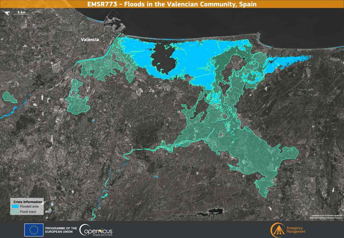
On 29 October 2024, the Community of Valencia in Spain has been hit by severe flooding, causing widespread devastation and the tragic loss of more than 200 lives. In response to the crisis, the Copernicus Emergency Management Service (CEMS) has been activated (EMSR773) to provide a comprehensive assessment of the extent of the flooding in the affected areas.
copernicEMSR773 res
Credit: European Union, Copernicus Emergency Management Service data

This data visualisation depicts the situation in the province of Valencia on 31 October 2024 at 18:02 UTC. It highlights areas directly affected by the floods, marked in blue, and areas with residual flood traces, indicated by light green lines. The map reveals that more than 53,000 hectares were affected by the floods, with more than 190,000 people and 3,200 km of roads potentially affected. More information is available here.

This information is essential for emergency response and future mitigation planning, demonstrating the essential role of Copernicus data in managing crises caused by extreme weather events.

Featured image credit: European Union, Copernicus Emergency Management Service data

Satellite Image: Canary Islands, Spain (s. calima event)
Image of the day: Saharan dust haze over the Canary IslandsNews

Image of the day: Saharan dust haze over the Canary Islands

A Saharan dust haze sweeping across the Canary Islands in mid-September 2025 brought poor air quality, rising temperatures, and heightened health risks to the archipelago.…
Muser NewsDeskMuser NewsDeskSeptember 19, 2025 Full article
Industrial smoke from coal-fired power plant - abstract image
G7 to phase out coal-fired power plants by mid-2030sNews

G7 to phase out coal-fired power plants by mid-2030s

Turin, Italy | AFP G7 ministers agreed a timeframe Tuesday for phasing out coal-fired power plants, setting as a goal the mid-2030s, in a move…
SourceSourceMay 1, 2024 Full article
Satellite image: Vipava Valley, Slovenia
Image of the day: Agricultural landscapes of Vipava Valley, SloveniaNews

Image of the day: Agricultural landscapes of Vipava Valley, Slovenia

This image, captured by the Copernicus Sentinel-2 satellite on 5 November 2024, highlights the Vipava Valley in southwestern Slovenia, a region known for its Mediterranean…
Muser NewsDeskMuser NewsDeskMarch 8, 2025 Full article