
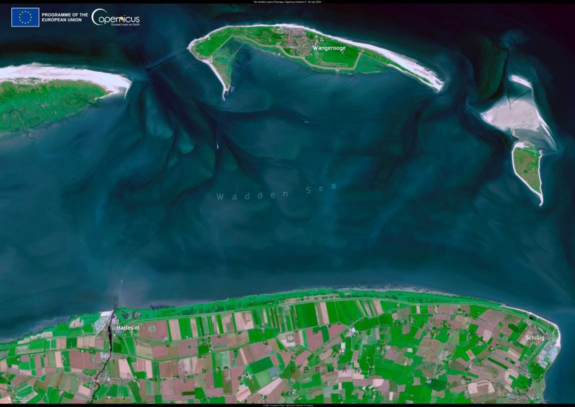
On Germany’s northern coast, the rising levels of the North Sea pose a threat to nearby communities and ecosystems. Encroaching sea water impacts not only sites along the shore, but also those further away by affecting farmland and habitats located more inland.

In the village of Harlesiel, as in many places along the shore, sea dikes are being built to protect the area from coastal erosion. The dimensions of the dikes are calculated based on predicted sea levels one century in the future, and work to protect the homes of over one million people in the German state of Lower Saxony.

Harlesiel Germany res
Credit: European Union, Copernicus Sentinel-2 imagery

The villages of Harlesiel and Schillig, along the northern coast of Germany, are visible in this image acquired by one of the Copernicus Sentinel-2 satellites on 20 July 2024.

The Copernicus Coastal Hub is an essential resource for Earth Observation data on European coastal zones. Its value-added information is useful for supporting sustainable management of these important areas.

Featured image credit: European Union, Copernicus Sentinel-2 imagery

Satellite Image: Image of a burn scar from wildfires south of Ciudad Altamirano in the Mexican state of Guerrero
Image of the day: Satellite captures scale of Mexico’s 2025 wildfire crisisNews

Image of the day: Satellite captures scale of Mexico’s 2025 wildfire crisis

A brutal wildfire season is tearing through Mexico, scorching vast swaths of forest and leaving blackened landscapes behind. Since January 2025, more than 2,800 forest…
Muser NewsDeskMuser NewsDeskApril 25, 2025 Full article
Image: Abstract globe (s. climate news, climate change, heat)
Innovative recycling method for rare earth metals wins Spark Award 2024News

Innovative recycling method for rare earth metals wins Spark Award 2024

Marie Amélie Perrin and Victor Mougel have been awarded the Spark Award 2024 for their groundbreaking method of recycling rare earth elements from electronic waste.…
Muser NewsDeskMuser NewsDeskNovember 23, 2024 Full article
Satellite Image: Žemaitija National Park, Lithuania
Image of the day: Forests and lakes of Žemaitija seen from spaceNews

Image of the day: Forests and lakes of Žemaitija seen from space

This satellite view captures Lithuania’s Žemaitija National Park, a protected area celebrated for its lakes, woodlands, and diverse wildlife. The image, taken by Copernicus Sentinel-2…
Muser NewsDeskMuser NewsDeskMay 21, 2025 Full article