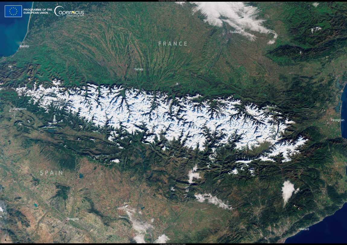
On December 15, 2024, the Pyrenees mountains experienced an intense snowstorm that transformed the landscape, affecting both sides of the mountain range.

In Spain, the Ebro Valley was shrouded in morning fog and coated with widespread frost, particularly in low-lying areas. These conditions created challenges for drivers, prompting authorities to issue safety advisories due to reduced visibility and slippery surfaces.

In France, the snowstorm’s impact was heightened by avalanche warnings across several departments in the western Pyrenees. Authorities emphasized the need for caution, as unstable snowpack conditions posed risks for outdoor activities and nearby communities.

Sattelite Image of the Pyrenees
The Pyrenees. Credit: European Union, Copernicus Sentinel-3 imagery

By December 16, as the skies cleared, the Copernicus Sentinel-3 satellite captured a vivid image of the Pyrenees, showcasing the expansive snow cover from space.

This open data from Copernicus Sentinel satellites plays a critical role in monitoring environmental changes in mountainous regions. By providing detailed information on snow cover, frost, and other conditions, these observations support evidence-based decision-making for safety and resource management in affected communities.

Featured image credit: European Union, Copernicus Sentinel-3 imagery

Graphic news (s. climate, science, research, scientists. emission targets, floods, environment)
Scholz cancels trip to next week’s COP climate summit: govtNews

Scholz cancels trip to next week’s COP climate summit: govt

Berlin, Germany | AFP - German Chancellor Olaf Scholz, fighting a political crisis after his ruling coalition collapsed, has cancelled his trip to next week's…
SourceSourceNovember 7, 2024 Full article
Satellite image: Philippines
Image of the day: The Del Carmen Mangrove Reserve, a recently designated Ramsar SiteNews

Image of the day: The Del Carmen Mangrove Reserve, a recently designated Ramsar Site

The Del Carmen Mangrove Reserve on Siargao Island in the Philippines was recently designated a Ramsar Site of International Importance. Spanning nearly 4,900 hectares, the…
SourceSourceNovember 28, 2024 Full article
Satellite Image: Amorgos Island, Greece
Image of the day: Calm August seas surrounding AmorgosNews

Image of the day: Calm August seas surrounding Amorgos

In the heart of the Southern Aegean, Amorgos stretches across the water as the easternmost island of the Cyclades, its elongated shape facing the smaller…
Muser NewsDeskMuser NewsDeskAugust 25, 2025 Full article