Nestled in Swedish Lapland, Kiruna is Sweden’s northernmost and largest municipality, stretching across vast Arctic terrain. Located about 200 kilometers north of the Arctic Circle, the region features an extraordinary mix of forests, marshes, rivers, and lakes, with Sweden’s highest mountain, Kebnekaise, standing among its dramatic landscapes. This environment makes Kiruna a prime destination for outdoor activities like hiking, skiing, and dog sledding.
The area is also home to the Kiruna Ground Station, a crucial hub for space operations that supports both the Copernicus and Galileo programs. The Copernicus Ground Segment plays a key role in receiving and processing satellite data, ensuring accurate transmission and monitoring satellite health.

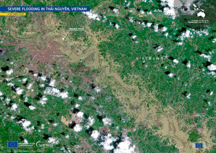
This Sentinel-2 satellite image, taken on September 15, 2024, highlights the Kiruna Ground Station at the center, with the Vittangiälven and Torne rivers flanking the area. To the west, the Sautusjärvi lake and the village of Jukkasjärvi are also visible.
Beyond its scientific importance, Kiruna is a city in transformation. Established as a mining town in 1900, it is undergoing a massive relocation due to the effects of iron ore extraction. Entire buildings are being moved to a new city center, with the historic Kiruna Church scheduled to be relocated in 2025. The city’s redevelopment, which began in 2022, is expected to be completed by 2035.
Kiruna is also known for its stunning celestial displays, from the Northern Lights that dance across the winter skies to the Midnight Sun that bathes the landscape in 24-hour daylight during the summer months. The Aurora Sky Station in nearby Abisko is one of the world’s best spots for observing the aurora, while Riksgränsen ski resort offers the rare opportunity to ski under the Midnight Sun well into June.
A city of science, nature, and transformation, Kiruna remains a remarkable part of Swedish Lapland, where tradition and innovation meet under the Arctic sky.
Featured image credit: European Union, Copernicus Sentinel-2 imagery