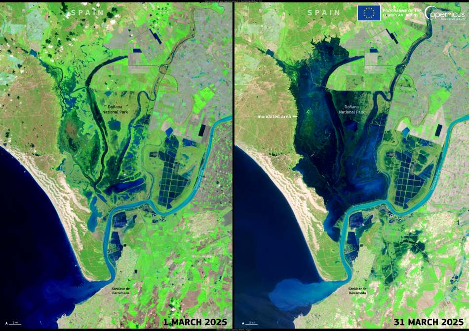
A dramatic hydrological shift unfolded in southern Spain over the course of March 2025, as intense rainfall events turned the desiccated marshes of Doñana National Park into vibrant wetlands once again. False-colour images from the Copernicus Sentinel-2 satellite illustrate the transformation, comparing the dry conditions on 1 March with a much wetter landscape by 31 March. The change is most evident in the central and western zones of the park, where water has returned to areas that were previously dry.
This is the most significant recharge of the Doñana wetlands in more than ten years, according to Spain’s environmental agencies. The rainfall has brought a much-needed influx of water to one of Europe’s most important biodiversity reserves. Years of persistent drought, aggravated by over-extraction of groundwater and climate change, had pushed the park’s aquatic habitats to the brink. Amphibians, waterfowl, and other species that depend on seasonal flooding were among the worst affected.

The recent inundation offers a chance for these fragile ecosystems to rebound. Rewetting the marshes supports the breeding cycles of amphibians and birds, restores natural vegetation, and helps improve the overall health of this UNESCO World Heritage Site. While the rainfall alone cannot resolve the long-term threats facing the Doñana region, it provides a critical window for recovery, especially if combined with improved water management and conservation measures.
The Copernicus Sentinel-2 images show the transformation from dry to flooded terrain. On the left, the scene from 1 March shows mostly dry terrain. On the right, the image from 31 March displays widespread inundation, with water pooling across the park’s marshes and extending outward into surrounding lowlands.
Through open-access data, the Sentinel satellites enable scientists, policymakers, and the public to track ecological change in near-real time. Doñana’s March revival, as seen from space, is a vivid reminder of nature’s resilience, and of the importance of monitoring our planet’s most vulnerable ecosystems.
Featured image credit: European Union, Copernicus Sentinel-2 imagery


