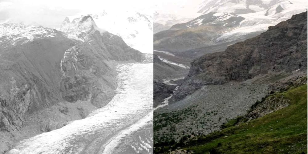
A new beach has formed along Poland’s northern coast, where the Vistula River empties into the Gulf of Gdańsk. Located near the village of Mikoszewo, the shoreline has been gradually expanding in recent years due to the deposition of sand and sediment transported by the river and shaped by Baltic Sea currents. In early February 2025, a significant new build-up extended the beach by roughly 100 metres.
This coastal change is visible in satellite imagery collected by the Copernicus Sentinel-2 mission. Comparing images from March 2017, March 2020, and March 2025, the shoreline’s progression is clearly apparent. In the latest image, a wide new strip of white sand appears east of the river’s mouth—marking a substantial addition to the coastal landscape.

Experts attribute the phenomenon to natural sediment dynamics. The Vistula is Poland’s longest river and carries a large sediment load into the Baltic Sea. At the river’s delta, the combination of fluvial discharge and prevailing sea currents causes sediment to settle and accumulate along the coast. Over time, this process has reshaped the shoreline near Mikoszewo, where changes have been especially visible over the past decade.
The beach’s sudden growth has sparked local interest, drawing visitors even in the off-season. Its popularity has prompted the Polish Post Office to assign it a new postal code — an unusual step for a beach formed purely by natural forces.
These coastal developments are monitored by the Copernicus Coastal Hub, which provides publicly available data and analysis tools for managing Europe’s coastlines. The new beach at Mikoszewo offers a real-world example of how natural processes continue to influence the geography of the Baltic region and how satellite data helps track those changes.
Featured image credit: European Union, Copernicus Sentinel-2 imagery