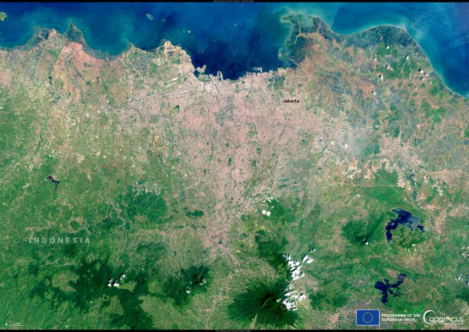
Home to more than 10 million people, Jakarta is Southeast Asia’s most populous city and the beating heart of Indonesia’s economy and culture. From above, the vastness of this urban sprawl comes into sharp focus. In this Copernicus Sentinel-2 image taken on 5 September 2024, Jakarta appears bordered by the Java Sea to the north and backed by the lush, volcanic terrain of West Java to the south. It’s a striking view of a megacity under pressure — both from within and from the changing climate.
Jakarta’s location on the northwest coast of Java Island places it in a low-lying delta plain, crisscrossed by rivers and wetlands. At an average elevation of just 8 metres above sea level, large swaths of the city are extremely vulnerable to flooding and coastal inundation. But it’s not only the seas that are rising — Jakarta itself is sinking.
According to a 2018 report by the World Economic Forum, parts of the city have been subsiding by as much as 25 centimetres per year, largely due to excessive groundwater extraction. The problem is most severe in the northern districts closest to the shoreline, where some neighbourhoods now lie below sea level. This land subsidence has been accelerating for years, increasing the risk of flood events, damaging infrastructure, and complicating Jakarta’s already daunting traffic and development challenges.

While groundwater extraction is a major factor, the city’s rapid urbanisation also plays a role. Paved surfaces have expanded relentlessly to accommodate Jakarta’s booming population, which includes millions more in the wider metropolitan area. This has reduced the natural ability of the ground to absorb rainwater, aggravating drainage problems and flash flooding during the rainy season.
Climate change adds a further layer of strain. As global temperatures rise, so do sea levels, and rainfall events have become more intense. A study published in Ocean & Coastal Management in 2024 highlighted how the combination of land subsidence and sea-level rise poses a serious threat to Jakarta’s long-term habitability and infrastructure. By some estimates, parts of the city could be permanently inundated within a few decades without significant intervention.
Monitoring these changes from space is critical, and that’s where the Copernicus Sentinel satellites come in. Operated by the European Union, the Sentinel-2 mission delivers high-resolution optical imagery that helps track ground movement, map urban growth, and observe environmental changes over time. This data is vital not only for Jakarta, but for other coastal cities around the world facing similar challenges.
Urban planners and local authorities increasingly rely on such satellite observations to inform flood management, coastal defense projects, and long-term strategies for resilience. In Jakarta, this includes the controversial plan to relocate the national capital to a new site on the island of Borneo — a move partly motivated by the growing environmental stress in the current capital.
But even as these long-term plans unfold, millions of Jakartans continue to live with the day-to-day consequences of environmental strain. Space-based monitoring, such as that provided by Sentinel-2, offers one of the clearest windows into how these forces are reshaping the land and the lives built upon it.
Featured image credit: European Union, Copernicus Sentinel-2 imagery


