A brutal wildfire season is tearing through Mexico, scorching vast swaths of forest and leaving blackened landscapes behind. Since January 2025, more than 2,800 forest fires have been recorded across the country, burning over 215,000 hectares of land, according to Mexico’s National Forestry Commission (Conafor). This marks 2025 as the third most damaging year on record in terms of area affected by fires during the first four months of the year.
The fires have spread across all 32 Mexican states, driven by prolonged drought conditions, high temperatures, and shifting weather patterns. Guerrero, Oaxaca, and the State of Mexico are among the hardest-hit regions, where rugged terrain and strong winds have made firefighting efforts particularly difficult. Authorities and local communities have been working to contain the flames, but the intensity and spread of the fires have overwhelmed many areas.
In the middle of this unfolding crisis, satellite imagery has become an essential tool in assessing the scale of destruction and guiding emergency responses.

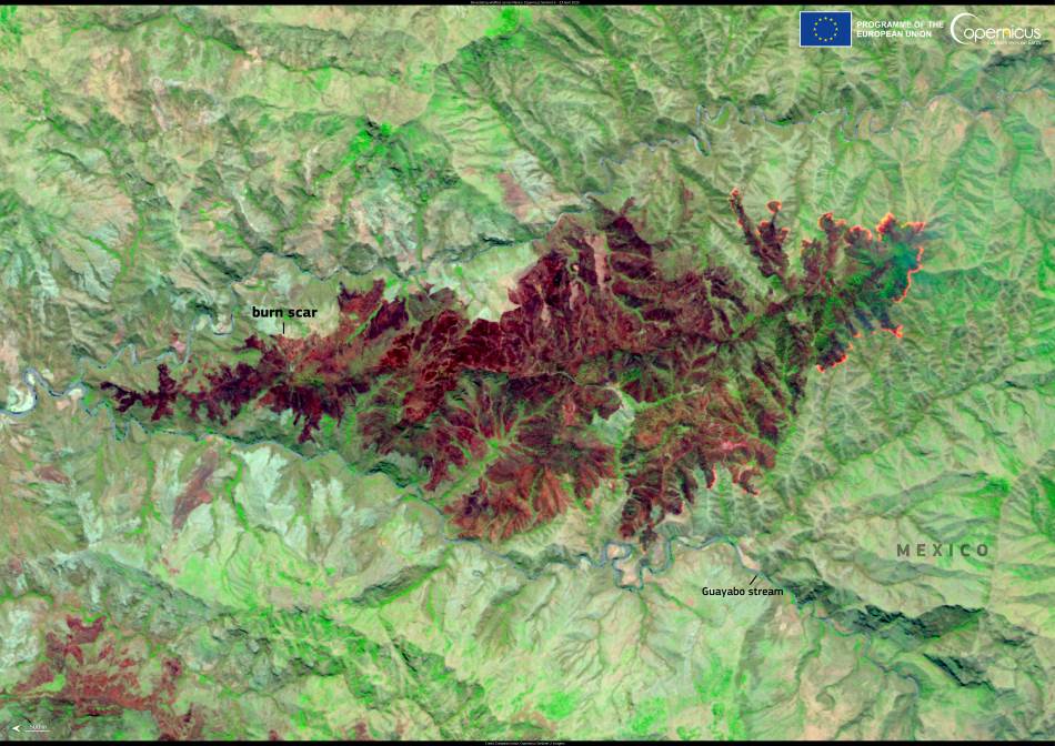
This false colour image acquired by one of the Copernicus Sentinel-2 satellites on 23 April 2025 shows a burn scar from wildfires south of Ciudad Altamirano in the Mexican state of Guerrero.
The dark reddish tones in the image reveal scorched vegetation and burnt terrain, while unburnt forest and vegetation appear in bright shades of green. False colour imagery helps distinguish between healthy and damaged land cover more clearly than natural colour photographs, making it an effective tool for analyzing the effects of fire on ecosystems.
Data collected from Sentinel-2 and other Copernicus Earth observation satellites is freely available to governments, researchers, and emergency services. This open data is instrumental in mapping the extent of wildfires, identifying hotspots, and helping agencies prioritize resources. It also supports long-term environmental assessments and recovery planning, such as evaluating reforestation needs or tracking carbon emissions from burnt biomass.
Mexico has long faced a challenging fire season during its dry months, but the scale and frequency of wildfires have increased in recent years. According to Mexico News Daily, more than 1.67 million hectares of land were affected by forest fires in 2024 — a number that suggests a continuing upward trend. Experts link this rise to a combination of human activity, land-use change, and shifting climate conditions that are making forests more flammable.
As the country heads into the hottest part of the year, the outlook remains uncertain. Authorities are urging the public to take extreme care in forested areas and avoid activities that could trigger new blazes. Meanwhile, satellite monitoring continues to provide a crucial, bird’s-eye view of the situation on the ground, helping officials respond to one of the most destructive fire seasons in Mexico’s recent history.
Featured image credit: European Union, Copernicus Sentinel-2 imagery


