Stretching across more than 101,000 hectares, the Serra da Estrela Natural Park stands as the largest natural conservation area in Portugal. Nestled within the Serra da Estrela mountain range — the highest in the country — the park is a vast, rugged landscape where glacial valleys, ancient rock formations, and rare ecosystems shape a unique environment. From the country’s highest peak, the Torre, visitors can take in sweeping views of a protected region rich in biodiversity and cultural heritage.
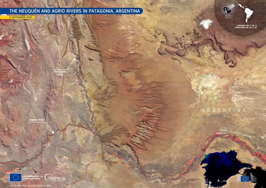
The Copernicus Sentinel-2 satellite captured this striking image of the park’s Estrela Mountain upper plateau and the upper Zêzere River on 23 April 2025. This section of the park has been recognized for its environmental significance and is protected under several conservation designations. It is part of a biogenetic reserve and a Natura 2000 site, affirming its value for both national and European biodiversity.

The landscape seen from space highlights a region shaped by both geological forces and climatic transitions. The area encompasses the upper mountain and plateau regions, the Candeeira valley, and stretches of the Zêzere River valley. This setting is particularly notable as it forms a transition zone between the temperate and Mediterranean macrobioclimates, giving rise to a rich mosaic of habitats. Alpine meadows, endemic plant species, glacial remnants, and rare fauna such as the Iberian wolf and golden eagle are part of this intricate natural tapestry.
Serra da Estrela Natural Park remains not only a symbol of Portugal’s wild beauty but also a testament to the importance of protecting Europe’s natural heritage, both from the ground and from space.
Data from the Copernicus Sentinel satellites, operated by the European Union’s Earth observation program, play a critical role in monitoring ecosystems like Serra da Estrela. By providing free and open access to high-resolution imagery, the Copernicus missions help scientists, conservationists, and policymakers track changes across sensitive landscapes, develop better conservation strategies, and respond to environmental challenges.
Monitoring the upper Zêzere River and the surrounding biogenetic reserve is vital to preserving the park’s ecological diversity for future generations.
Featured image credit: European Union, Copernicus Sentinel-2 imagery