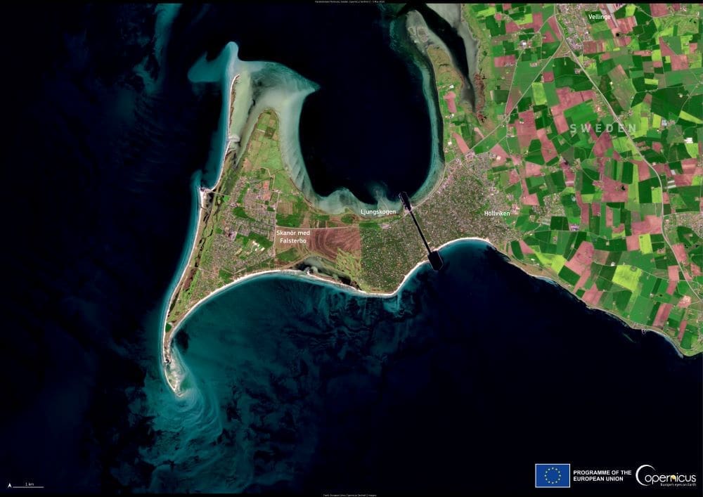
At the southwestern edge of Sweden, the Falsterbonäset peninsula stretches into the sea like a narrow, windswept finger, bordered by the Öresund Strait to the west and the Baltic Sea to the south and east. This low-lying spit of land connects to the mainland near Höllviken and forms a distinctive coastal landscape shaped by centuries of wind, waves, and sand.
Falsterbonäset is known not only for its picturesque seaside towns — Falsterbo and Skanör — but also for its expansive beaches, dune systems, and rich wetlands. Historically a trading hub and fishing region, it has evolved into one of southern Sweden’s most popular summer destinations, offering swimming, sailing, and cycling along its scenic coastline. The area’s flat, open terrain also makes it especially favorable for outdoor activities and nature tourism.
Ecologically, the peninsula holds national significance. Its mix of heathland, marshes, and shallow coastal waters provides important breeding grounds and feeding habitats for birds and other wildlife. Every spring and autumn, Falsterbonäset becomes a key migration corridor for hundreds of thousands of birds, including raptors and songbirds that funnel through the narrow land bridge before crossing open water. This has made it a major destination for birdwatchers and ornithologists.

The image above, acquired by the Copernicus Sentinel-2 satellite on 5 May 2025, shows the peninsula’s shape and surrounding shallows in high resolution. The light coloration in the waters reveals submerged sandbanks and shifting seabeds — features that contribute to the dynamic nature of this coastal zone. Sentinel data like this allows scientists to monitor erosion, vegetation health, and habitat changes over time.
The Copernicus Sentinel programme, operated by the European Space Agency, provides free and open satellite data to support environmental monitoring across Europe. In places like Falsterbonäset, this helps inform sustainable planning and conservation efforts to ensure the region’s natural and cultural values are protected.
With its combination of natural beauty, ecological richness, and cultural heritage, Falsterbonäset remains one of Sweden’s most distinctive coastal landscapes — where land, sea, and sky converge in constant motion.
Featured image credit: European Union, Copernicus Sentinel-2 imagery


