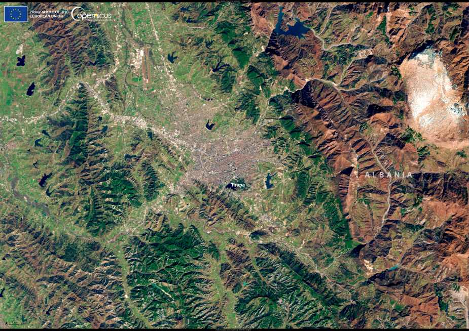
In this Copernicus Sentinel-2 satellite image acquired on 6 March 2025, Tirana, the capital and largest city of Albania, stretches across the central-western lowlands of the country. The city’s distinctive geography emerges clearly in the image: built on a fertile plain and framed by the Dajti mountain range to the east and rolling hills to the south and west, Tirana is a striking example of a rapidly changing European capital. From above, the dense urban core contrasts with patches of green space and surrounding farmland, revealing the city’s evolving relationship with its natural environment.
Tirana lies about 30 kilometers inland from the Adriatic Sea, with coordinates approximately 41.33°N latitude and 19.82°E longitude. The city is bisected by the Lana River, a narrow waterway that runs from east to west, while the larger Tirana River skirts the northern edge. These rivers, though modest in size, have played a role in shaping urban development patterns and present ongoing opportunities and challenges for water management and flood control.
In the satellite image, the bright linear patterns of new roads and expanding neighborhoods can be seen radiating from the city center, reflecting rapid urbanization. Since the 1990s, Tirana has experienced significant demographic and spatial growth, more than doubling its population. As of 2024, the metropolitan area is home to around one million residents — nearly one-third of Albania’s entire population. The city has become the country’s dominant economic engine and administrative center, drawing migrants from across the region.

Urban transformation has been a major focus for Tirana’s leadership, particularly over the past two decades. Large-scale projects have aimed to reorganize traffic, pedestrianize central areas, and invest in public parks. The Grand Park of Tirana (Parku i Madh), located around the Artificial Lake in the southern part of the city, is a major recreational space visible in the image as a dark green expanse. North of the park, Skanderbeg Square — a major civic landmark named after Albania’s national hero — is surrounded by government buildings, cultural institutions, and religious sites. These include the Et’hem Bey Mosque and the National Historical Museum, whose mosaic façade commemorates Albania’s complex history.
Efforts to green the city are evident in projects like the Orbital Forest initiative, which aims to encircle Tirana with a belt of newly planted trees, and the “Green City Action Plan,” which promotes sustainable mobility, waste management, and energy efficiency. Some of these green corridors and vegetation zones are beginning to show in satellite imagery, particularly in suburban areas where reforestation and landscaping projects are underway.
The Sentinel-2 image also highlights Tirana’s outward expansion. Residential developments, often built quickly to meet housing demand, extend into the surrounding countryside. While this urban sprawl raises concerns about land use and infrastructure strain, it also presents opportunities for smarter urban planning using Earth observation tools.
Copernicus Sentinel-2, operated by the European Space Agency (ESA), delivers high-resolution optical imagery that is invaluable for urban monitoring, environmental assessment, and land cover mapping. Open access to this data helps urban planners, environmental researchers, and municipal authorities monitor change over time and design more sustainable growth strategies.
Tirana’s modern development stands in contrast to its layered past, shaped by Roman, Byzantine, Ottoman, and communist influences. Though it became Albania’s capital only in 1920, the area has been inhabited since antiquity. Today, the city is a vivid example of post-socialist transformation, with eclectic architecture, dynamic street life, and ongoing debates about heritage preservation amid new development.
As the image shows, Tirana’s terrain, urban form, and surrounding landscapes are all part of a complex system in flux. Satellite data like this not only reveals the physical shape of the city but also supports more data-driven decisions about its future — whether in transport, climate resilience, or managing tourism in a rapidly modernizing capital.
Featured image credit: European Union, Copernicus Sentinel-2 imagery


