Wildfires burning across western Canada since May 2025 have forced thousands to evacuate and filled the skies with dense smoke. Alberta, Saskatchewan, and Manitoba have each seen large areas of boreal forest consumed, with emergency officials ordering evacuations in several communities as conditions worsened.
In Saskatchewan, where some of the largest fires have occurred, smoke has drifted eastward and southward, contributing to hazardous air pollution in parts of Canada and the United States. The scale of these fires has sent thick smoke high into the atmosphere, reducing visibility and degrading air quality across a wide area of North America.

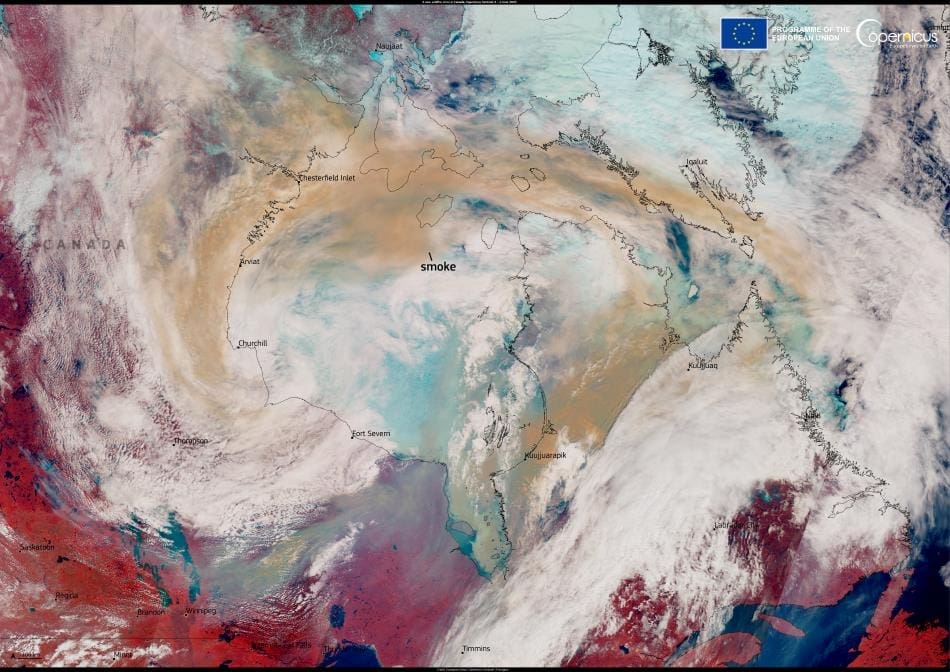
The image above, acquired by a Copernicus Sentinel-3 satellite on 4 June 2025, shows a large brown smoke plume circulating over the Nunavut and Hudson Bay regions. Transported by atmospheric currents, the smoke illustrates how far pollution from these fires has traveled.
According to the Copernicus Atmosphere Monitoring Service (CAMS), estimated wildfire carbon emissions in May and early June for Alberta, Saskatchewan, and Manitoba were significantly higher than average. CAMS has tracked the movement of smoke plumes from these fires beyond North America, noting that some of the smoke has already reached parts of Europe. CAMS is continuing to monitor the situation as the smoke spreads further across the Atlantic.
The fires have added new pressure to emergency services and raised concerns about the early intensity of Canada’s 2025 wildfire season. With dry conditions persisting, authorities remain on high alert across multiple provinces.
Featured image credit: European Union, Copernicus Sentinel-3 imagery


