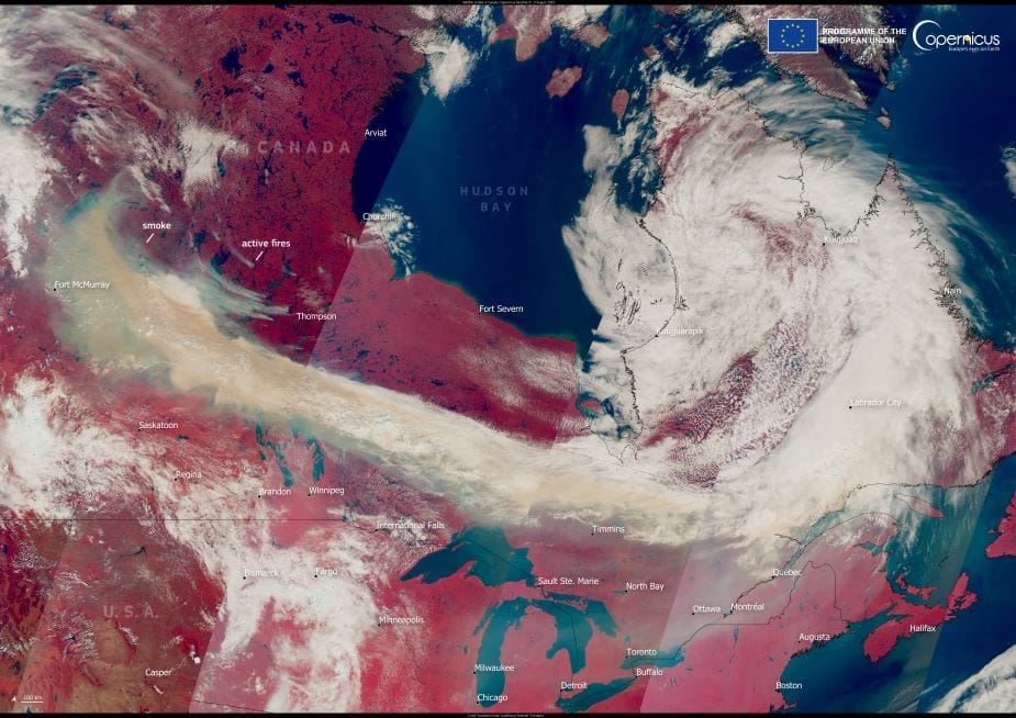
Vast plumes of wildfire smoke have swept across Canada and into the United States as an intense fire season continues to grip large parts of western and central Canada. Hundreds of wildfires are currently burning across Saskatchewan, Alberta, and Manitoba, prompting mass evacuations and deteriorating air quality across the region and beyond.
This false colour image, captured by a Copernicus Sentinel-3 satellite on 3 August 2025, shows thick smoke stretching from western Canada deep into the United States. The swirling grey patterns represent dense aerosol clouds drifting eastward, visibly altering skies over multiple states and provinces.

Throughout June and July, Canada experienced exceptionally severe wildfire conditions. According to the Copernicus Atmosphere Monitoring Service (CAMS), wildfire intensity and smoke emissions remained consistently above average levels for the period 2003–2024, marking one of the most extreme summer fire seasons in over two decades.
The CAMS team continues to monitor these events in near real-time, providing critical data to support air quality forecasting and emergency response. Satellite observations like those from Copernicus Sentinel-3 allow scientists to assess the spread and impact of wildfire smoke across continents.
As wildfires burn across boreal forests, smoke-laden air has contributed to hazardous conditions in multiple Canadian provinces and U.S. states. Public health advisories have been issued in affected regions, with authorities urging residents to stay indoors when possible.
Copernicus data play a vital role in mapping the extent of wildfires and tracking long-range smoke transport, supporting coordinated efforts to manage air quality and public health risks.
Featured image credit: European Union, Copernicus Sentinel-3 imagery


