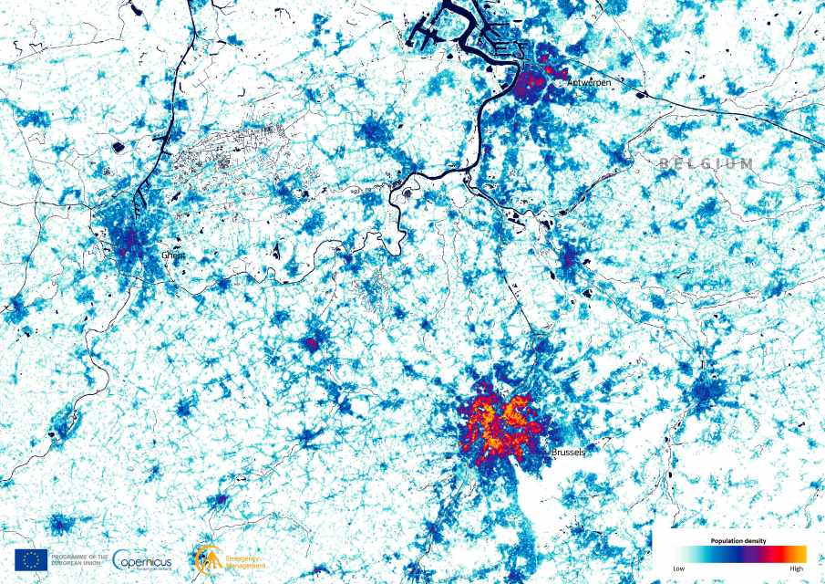
Population density in northern Belgium is projected to intensify by 2030, according to a new visualisation created with data from the Copernicus Emergency Management Service Global Human Settlement Layer (GHSL). The GHSL provides high-resolution mapping of human presence worldwide, giving researchers, planners, and policymakers a detailed picture of where people live, how cities grow, and how development pressures may evolve in the coming years.
The forecasted map highlights a tightly concentrated urban core, shown in red and orange, surrounded by areas of lower residential density. For Belgium, one of Europe’s most densely populated countries, such projections are valuable for anticipating future demands on housing, transportation networks, and essential services.

The GHSL is not only used for long-term planning but also plays a role in crisis management. Its data supports disaster preparedness and response by showing where populations are most at risk, from floods and earthquakes to wildfires and heatwaves. By integrating demographic and spatial information, it enables authorities to identify vulnerable areas and allocate resources more effectively.
Urban development is another key application. As cities continue to expand, particularly in Europe’s densely built regions, GHSL data helps track the pace of change and provides evidence for sustainable planning. Comparing past and present maps with future forecasts makes it possible to evaluate trends in land use, urban sprawl, and the relationship between settlement growth and environmental pressures.
The image, produced using Copernicus GHSL data, shows the population distribution expected in 2030 in northern Belgium.
More information about the GHSL and its applications is available on the Copernicus Emergency Management Service website.
Featured image credit: European Union, Copernicus Emergency Management Service


