The Lafnitz River winds through southeastern Austria, shaping a landscape defined by constant movement. Stretching about 110 kilometers, it flows from its source in Styria above Lafnitzeck, forming much of the border between Styria and Burgenland before joining the Raab River south of Fürstenfeld. With its meanders, oxbow lakes, sandbanks, and floodplain forests, the Lafnitz remains one of Austria’s few lowland rivers where natural processes still dominate.
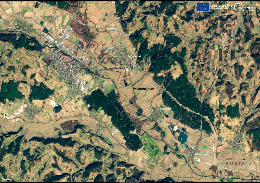
This Copernicus Sentinel-2 image, acquired on 7 March 2025, captures the river curving past the towns of Fürstenfeld, Rudersdorf, and Dobersdorf. Agricultural plots surround the watercourse, yet in many stretches the Lafnitz has avoided the heavy river engineering seen elsewhere, retaining its natural meanders and dynamic flow. Its shifting channels, sediment deposits, and gallery woods make it an important refuge for biodiversity and a living example of dynamic river equilibrium.

The river’s gradient gradually decreases from 15 ‰ in its upper course to just 1.2 ‰ in its lower reaches. This slowing flow, combined with dense bank vegetation, reduces velocity and encourages the buildup of natural embankments, which rise steeply on the river side and slope gently toward the floodplain. As a result, the Lafnitz does not always run at the lowest point of its valley, giving it a distinctive raised character.
Recognized for its ecological value, the Lafnitz and its adjacent wetlands are part of the NATURA 2000 network and were designated a Ramsar site in 2002. Roughly 300 hectares serve as natural flood protection areas, while another 400 hectares are under management restrictions to balance agriculture and conservation. The river is also a reference system under the EU Water Framework Directive for “near-natural lowland rivers.”
Conservation efforts are supported by the LIFE IP IRIS project, Austria’s first integrated LIFE initiative, which runs from 2019 to 2027 with €16.5 million in funding. Led by Austria’s Federal Ministry of Agriculture, the project brings together regional water management authorities, the Federal Environment Agency, and viadonau to safeguard the Lafnitz and other rivers. Restoration measures have removed migration barriers, reconnected habitats, and reinforced the Lafnitz’s role as a model for natural river management.
Featured image credit: European Union, Copernicus Sentinel-2 imagery


