Weeks of intense monsoon rains have left vast stretches of Punjab in Pakistan underwater, displacing millions of people and inundating farmland on an unprecedented scale. The Sutlej, Chenab, and Ravi rivers have all burst their banks following record rainfall and upstream dam releases, turning much of the province’s southern plains into a sprawling flood zone.
Authorities estimate that more than 4 million people have been affected across eastern Punjab, with about 2.5 million displaced from their homes and over 4,000 villages inundated. At least 100 people have died in the province, while access to clean water and electricity has been cut off in large areas. More than 1 million acres of cropland are underwater, threatening the livelihoods of countless farming families. Many rural communities have been reachable only by boat for days, with relief supplies struggling to get through.

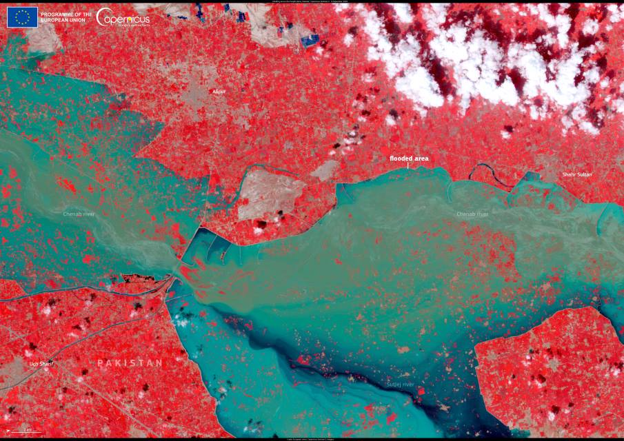
This satellite image, acquired by one of the Copernicus Sentinel-2 satellites on 9 September 2025, shows widespread flooding near the city of Alipur and along the courses of the Chenab and Sutlej rivers. Blue tones highlight inundated land stretching across the plains, where floodwaters have submerged roads, fields, and entire settlements.
Open data from the Copernicus Sentinel satellites allow authorities and humanitarian agencies to track the extent of flooding in near real time, helping them direct evacuations, plan relief efforts, and restore basic services. As floodwaters continue to move through the river systems, these observations are playing a central role in coordinating the response and assessing the damage across Pakistan’s most populous province.
Featured image credit: European Union, Copernicus Sentinel-2 imagery


