Severe flooding in Niger has left hundreds dead and displaced thousands of families, with the Maradi region among the hardest hit. Heavy rainfall between 9 and 15 September caused widespread destruction across the country, overwhelming communities and infrastructure.
According to the United Nations Office for the Coordination of Humanitarian Affairs (UN OCHA), nearly 268,000 people had been affected across 53 departments by 15 September, with Maradi bearing the heaviest toll. The region has recorded 35 deaths, along with widespread destruction of homes and farmland and major disruption to education. More than 26,000 houses have been destroyed, 1,100 schools damaged, and 316 classrooms converted into temporary shelters for displaced families, leaving around 26,000 students without lessons just weeks before the new school year.

At national level, on 6 September the General Directorate of Civil Protection of Niger reported that floods had killed at least 273 people and affected more than 710,000. Over 73,000 houses had been destroyed, while livestock, health posts, shops, and crops were also lost. The southwestern regions of Tahoua and Maradi were the most affected, with 87 and 86 deaths respectively.
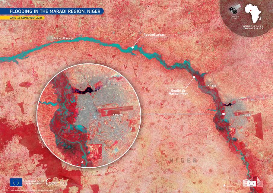
In this image, acquired by one of the Copernicus Sentinel-2 satellites on 15 September, floodwaters along the Goulbi de Maradi River and surrounding areas appear in shades of blue, clearly marking the scale of inundation around the city of Maradi.
Data from the Copernicus Services and Sentinel satellites provide vital support for monitoring disasters of this scale. Open-access imagery helps authorities and humanitarian organizations track the extent of flooding, guide relief operations, and plan recovery in one of the most vulnerable regions of West Africa.
Featured image credit: European Union, Copernicus Sentinel-2 imagery


