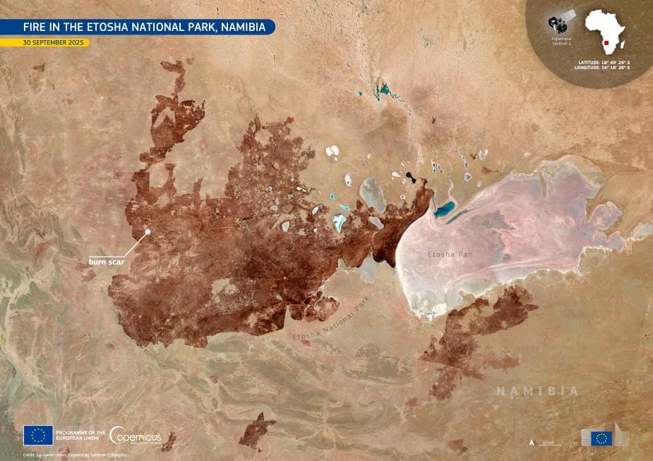
A vast fire has scorched a third of Namibia’s Etosha National Park – one of southern Africa’s largest and most iconic wildlife reserves – leaving behind a dark burn scar now visible from space.
The blaze, which erupted around 22 September 2025, is believed to have started at a charcoal production site outside the park. Fanned by strong winds and fueled by dry vegetation, it rapidly spread across hundreds of thousands of hectares of grassland and beyond the park’s boundaries into regions bordering Angola.
Etosha, famous for its vast salt pan and rich biodiversity, spans 22,935 square kilometres and hosts 114 mammal species, including the critically endangered black rhinoceros. Authorities confirmed the deaths of at least nine antelopes, while reports of an elephant death remain unverified. Despite the scale of destruction, no human casualties have been reported.

This Copernicus Sentinel-2 image, captured on 30 September 2025, reveals the charred landscape left by the fire. The darkened burn scar contrasts sharply with the surrounding unburned terrain, illustrating the vast reach of the flames across one of Africa’s premier conservation areas.
The government deployed helicopters and more than 500 soldiers to assist firefighters, police, and volunteers in suppressing the flames after an emergency cabinet meeting. Officials acknowledged that the blaze posed “a significant threat to the biodiversity, wildlife and livelihood of the communities in the affected areas.”
Experts note that wildfires are a natural occurrence in arid savannahs and can help sustain healthy ecosystems when managed properly. However, this fire has destroyed about 30 % of Etosha’s grazing areas and is expected to affect wildlife and tourism for years to come.
Featured image credit: European Union, Copernicus Sentinel-2 imagery


