Covering about 120 kilometres in width, the Thwaites Glacier in West Antarctica plays a critical role in regulating global sea levels. It drains a large portion of the West Antarctic Ice Sheet into the Amundsen Sea and is one of the most closely monitored glaciers on Earth because of its accelerating loss of ice. Scientists warn that if Thwaites were to collapse completely, global sea levels could rise by around 65 centimetres, with a risk of further increases if neighbouring ice sectors destabilise.
Recent research has revealed that the glacier’s retreat is driven not only by surface melting but also by tidal currents that carry warm ocean water beneath the ice. These subsurface flows melt the glacier’s base and cause its grounding line to move inland, accelerating overall retreat. Studies suggest Thwaites currently loses around 50 billion tons of ice each year, contributing about 4% of global sea level rise. Other modelling work indicates the glacier might be less prone to rapid marine ice cliff collapse than once feared, suggesting a slower but still steady loss of ice over time.

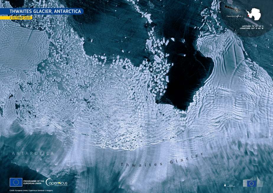
This Copernicus Sentinel-1 image, acquired on 2 October 2025, shows the vast ice tongue of Thwaites Glacier, with newly calved ice fragments drifting in the Amundsen Sea. Sentinel-1’s radar imaging allows scientists to observe these remote regions year-round, even through cloud cover or darkness, supporting precise tracking of calving events and changes in glacier flow.
The accelerating changes at Thwaites have also led some researchers to explore potential geoengineering measures aimed at slowing ice retreat. Proposals under discussion include underwater curtains designed to block warm water from reaching the glacier’s base. While such concepts remain theoretical and controversial, they reflect the growing concern about the glacier’s contribution to future sea level rise and its potential role as a tipping point for the West Antarctic Ice Sheet.
The Copernicus Sentinel-1 mission remains a key source of continuous polar monitoring, providing essential data for climate and glaciological research. The upcoming Sentinel-1D satellite, scheduled for launch from Europe’s Spaceport in Kourou, French Guiana, on 4 November 2025, will expand this capability, ensuring uninterrupted observation of dynamic regions such as Thwaites and improving the long-term record of ice movement and melt patterns.
Featured image credit: European Union, Copernicus Sentinel-1 imagery


