In early October 2025, northern Vietnam was hit by record-breaking floods that submerged streets, damaged homes, and forced mass evacuations across several provinces. Water levels in major rivers reached their highest in nearly four decades, leaving at least 18 people dead or missing and tens of thousands displaced.
The city of Thái Nguyên, about 80 kilometres north of Hanoi, saw the Cầu River peak at 29.9 metres on 8 October – more than a metre above the previous record set in September 2024. Entire neighbourhoods, shops, and streets were submerged under up to two metres of water, with rescue teams navigating flooded areas to reach stranded residents.

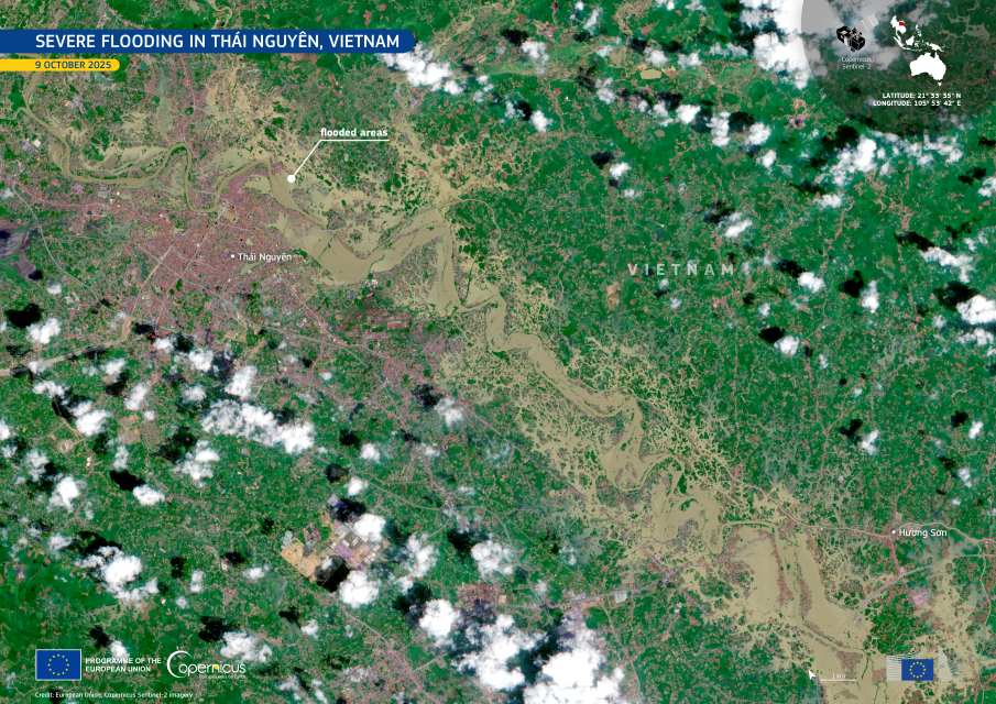
This Copernicus Sentinel-2 image, acquired on 9 October, shows extensive flooding along the Cầu River near Thái Nguyên. The dark brown and black areas reveal inundated land across 33 communes under water, illustrating the extent of the overflow from the swollen river system.
Heavy rains from Typhoon Matmo have wreaked havoc on northern Vietnam, particularly in Hanoi’s outskirts, leaving at least 18 dead or missing. Local media report that nearly 22,600 hectares of crops were destroyed, hundreds of thousands of livestock were swept away, and around 17,000 homes were flooded across four provinces – Thái Nguyên, Cao Bang, Bac Ninh, and Lang Son – including over 5,000 in Thai Nguyen..
The military mobilised around 30,000 personnel, thousands of boats, and three helicopters to deliver food, water, and lifejackets. Relief operations also intensified in Hanoi’s outskirts, where floodwaters on the Cầu and Cà Lồ rivers rose more than two metres above alarm level 3. Water levels have since begun to recede, though authorities warned that flooding could persist for several days due to slow drainage.
In Lang Son province, a dam burst at the Bac Khe 1 hydropower plant forced the evacuation of more than 200 families and caused about $1.9 million in damage.
Open data from the Copernicus Services and Sentinel satellites supports consistent global monitoring of flood events, providing vital information for response and recovery operations to help protect affected communities.
Featured image credit: European Union, Copernicus Sentinel-2 imagery


