Severe flooding has struck central and eastern Mexico in October 2025 after torrential rainfall from two tropical storms converging off the Pacific coast. The storms triggered landslides and river overflows that have devastated hundreds of mountain communities, with the village of Chapula among the hardest hit.
At least 76 people have died, dozens are missing, and more than 300 towns have been cut off by collapsed roads and bridges. Thousands of soldiers and workers are engaged in rescue operations, clearing routes and delivering food and water to isolated areas. In Hidalgo, Veracruz, and Puebla – the most affected states – flooding rivers and mudslides damaged or destroyed around 100,000 homes. Veracruz recorded more than 24 inches of rain in just four days, affecting over 300,000 residents.

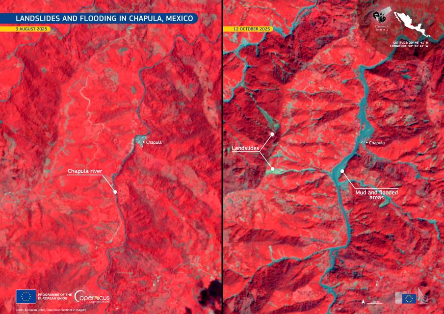
These false-colour Copernicus Sentinel-2 images show the dramatic extent of flooding along the Chapula River. In the image from 12 October 2025, vast blue areas reveal inundated land compared with the 3 August 2025 image. Vegetation, shown in red, appears submerged in several locations, and multiple large landslides are visible across the surrounding hills.
In Chapula, nearly the entire village was swept away by the river’s sudden rise, leaving only a few buildings standing. Local residents and volunteers organized their own rescue and supply missions using helicopters and on-foot deliveries to reach cut-off settlements.
Open-access data from the Copernicus Sentinel satellites provide essential monitoring of global flooding events. This information supports emergency response, helps assess damage, and aids recovery efforts in affected regions.
Featured image credit: European Union, Copernicus Sentinel-2 imagery


