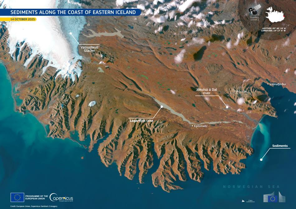
Sediments along the coast of eastern Iceland trace the path of meltwater flowing from Vatnajökull, Europe’s largest glacier. The Jökulsá á Dal – one of Iceland’s longest rivers at around 150 km – carries fine glacial silt from the highlands to the Norwegian Sea, shaping the region’s landscape and influencing its coastal waters.
As the river moves through the rugged terrain, it passes into Lagarfljót Lake, a long, narrow body of water often described as both a river and a lake. Here, suspended sediments begin to settle, turning the lake’s surface a pale, opaque hue. In early October, the river’s discharge reaches its peak as meltwater and highland floods combine, flushing vast amounts of mineral-rich material toward the coast.

This Copernicus Sentinel-2 image, captured on 14 October 2025, shows a striking sediment plume extending about 25 km northeast from Héraðssandur Bay. The plume forms where glacial meltwater meets the sea, creating swirling patterns of light and dark tones as fine sediments spread across the coastal shallows. The Vatnajökull Glacier can be seen to the left, its icy expanse feeding the system that continually reshapes Iceland’s eastern shores.
Glacial sediments, often composed of silt and clay ground from volcanic rock, play an important role in shaping Iceland’s landscapes. They enrich downstream soils, build up coastal plains such as the sandar of Héraðssandur, and influence the color and productivity of nearby marine waters. By tracking these patterns, scientists can better understand how glacial melt and river discharge respond to seasonal and long-term climate shifts.
Open-access Copernicus data provides a valuable record of these processes, offering a clearer picture of how sediment dynamics connect Iceland’s glaciers, rivers, and coastal environments.
Featured image credit: European Union, Copernicus Sentinel-2 imagery


