On World Cities Day, 31 October 2025, attention turns to Dublin, Ireland’s capital, where rapid urban growth intersects with historic streets, cultural hubs, and natural landscapes. The city’s evolution highlights the challenges and opportunities facing many European urban centres as populations grow and infrastructure demands increase.
Managing this growth requires precise, up-to-date spatial information to guide planning, preserve green areas, and maintain quality of life. Urban mapping tools provide a critical foundation for understanding where development is concentrated, how land is used, and where interventions are needed.
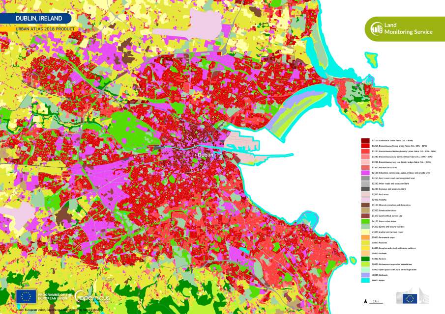
This image, produced using the Urban Atlas 2018 dataset from the Copernicus Land Monitoring Service, shows Dublin’s urban fabric with high thematic accuracy. Dense residential areas appear in deep red, industrial zones in purple, and parks, forests, and coastal features in green and blue. Transport networks, mixed-use districts, and natural spaces are all clearly delineated, revealing the patterns of urban expansion and the balance between built and natural environments. Such visualizations allow city planners to anticipate sprawl, protect green corridors, and prioritize infrastructure projects that meet both social and environmental needs.

Copernicus land monitoring supports sustainable urban development by delivering harmonised, high-resolution data. For Dublin, this information underpins strategies that foster resilience, inclusivity, and better access to essential services. It also aligns with global efforts to ensure that urban growth benefits residents equitably.
As the 2025 Global Observance of World Cities Day takes place today in Bogotá, Colombia, the theme People-Centred Smart Cities highlights how technology, data, and AI can improve urban living while keeping human needs, accessibility, and inclusivity central. The theme encourages smart city initiatives that tackle housing, mobility, and governance challenges while promoting citizen engagement and equitable development, with Dublin’s urban landscape offering a clear visual example of these priorities.
World Cities Day, first observed in 2014, concludes Urban October, a month dedicated to examining urbanization trends and challenges worldwide. Each year, the UN chooses a different host city and theme to highlight aspects of sustainable city planning.
The observance aligns with Sustainable Development Goal 11, which aims to make cities inclusive, safe, resilient, and sustainable. It encourages international cooperation, exchange of best practices, and strategic planning to ensure urbanization works for all residents rather than exacerbating inequality.
Dublin’s mapped urban fabric, as captured in the Copernicus image, reflects these global priorities – showing how understanding the city’s structure is the first step toward building inclusive, well-managed, and sustainable cities for the future.
Featured image credit: European Union, Copernicus Land Monitoring Service


