The Planchón-Peteroa volcanic complex, an elongated system of overlapping calderas along the Chile–Argentina border, has been active since the Pleistocene. Its volcanic history began with the formation of the basaltic andesite to dacitic Volcán Azufre, followed by the basaltic and basaltic andesite Volcán Planchón about six kilometres to the north.
Around 11,500 years ago, a large sector collapse of Azufre and part of Planchón generated the Río Teno debris avalanche, which travelled roughly 95 kilometres into Chile’s Central Valley. Later eruptions built Volcán Planchón II, while the youngest volcano in the complex, Volcán Peteroa, formed between Azufre and Planchón and hosts a small steaming crater lake. Eruptions from the complex have generally been explosive, with lava flows recorded in 1837 and 1937.
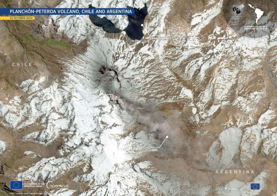
On 25 October 2025, Planchón-Peteroa emitted a sustained plume of volcanic gas and fine ash that rose about 600 metres above the crater. Initially drifting north-north-west, the plume shifted eastward later in the day as wind conditions changed, carrying ash across the Andes into Argentine territory.

The Copernicus Sentinel-2 satellite captured this image on 25 October 2025, showing the volcanic complex with a distinct ash plume extending eastward from the summit area. Ash is visible over the snow-covered slopes and spreading into Argentina, where light ash fall was reported in sectors of Mendoza province.
Monitoring cameras recorded a continuous column of volcanic gas and fine ash with variations in density throughout the day. Seismic data showed stable tremor levels, comparable to those of previous days. Only one minor volcano-tectonic event, related to rock fracturing, was detected overnight, without immediate implications for eruptive behaviour.
Forecasts from the Buenos Aires Volcanic Ash Advisory Center (VAAC) had already anticipated the eastward shift of the plume, enabling authorities to follow its dispersion in real time. The technical alert level remains unchanged, as the activity continues within expected parameters, though additional low to moderate eruptive pulses are possible.
The Copernicus Sentinel satellites provide vital data for tracking volcanic activity worldwide, helping scientists and civil protection agencies assess eruption dynamics and their potential impacts on nearby communities and air operations.
Featured image credit: European Union, Copernicus Sentinel-2 imagery


