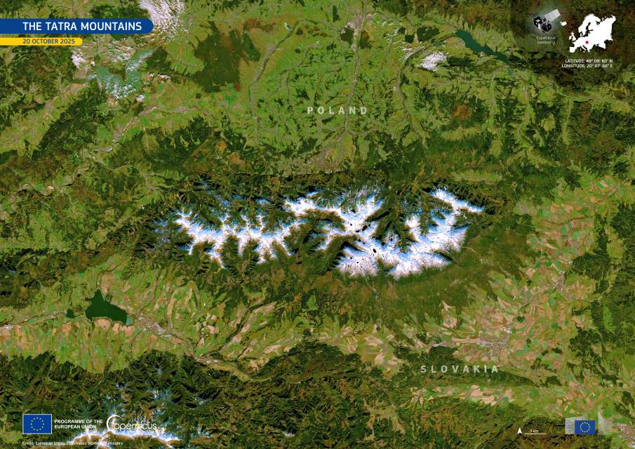
Stretching across southern Poland and northern Slovakia, the Tatra Mountains form the highest section of the Western Carpathians and one of Central Europe’s most striking alpine landscapes. Their dramatic peaks, glacial valleys, and pristine lakes have earned them protection on both sides of the border through the establishment of two national parks – the Tatra National Park in Poland and Tatranský národný park in Slovakia. In 1992, UNESCO jointly designated these parks as a transboundary biosphere reserve under its Man and the Biosphere Programme, recognising their unique natural value and ecological diversity.
Geomorphologically, the Tatras are remarkable for their concentration of glacial forms, including cirques, amphitheatres, and U-shaped valleys shaped during the Pleistocene glaciations. These ancient ice sheets sculpted the rugged relief that defines the mountain range today. Peaks such as Gerlach (2,654 m) and Lomnický štít (2,629 m) rise sharply from a system of ridges and lateral valleys, while remnants of glacial activity – moraines, ravines, and alpine lakes – remain integral features of the landscape.
The region’s lakes, known as plesá in Slovakia and stawy in Poland, are among the most distinctive elements of the High Tatras. Formed by a combination of glacial hollowing and moraine damming, these lakes trace the history of the last Ice Age, which ended around 10,000 years ago. On the Slovak side, there are about 165 lakes, most situated in the sub-alpine and alpine zones above the forest line. Veľké Hincovo pleso is the largest and deepest, reaching a depth of 53 m, while on the Polish side, Morskie Oko covers 34.9 ha and Wielki Staw – at 79.3 m – is the deepest of all Tatras lakes.
Many of these alpine lakes remain frozen for nearly half the year, with ice sometimes persisting through summer at higher altitudes.

The Tatra Mountains, visible in this Copernicus Sentinel-2 image acquired on 20 October 2025, form a natural border between southern Poland and northern Slovakia. The region typically receives its first snowfall in late October, whereas the surrounding lowlands remain snow-free until later in the season. Through high-resolution optical imaging, the Copernicus Sentinel-2 satellites provide crucial insights into land use, vegetation health, and snow cover dynamics. This information supports conservation efforts and helps develop climate resilience strategies in mountain ecosystems.
The Tatras also represent a meeting point of diverse habitats – from subalpine meadows and dwarf pine forests to alpine tundra and rocky summits. This variety supports many rare and endemic species, including the Tatra chamois (Rupicapra rupicapra tatrica) and the marmot (Marmota marmota latirostris). The protection of these fragile habitats is central to the management of both national parks and to UNESCO’s transboundary biosphere framework.
The Copernicus Programme, coordinated by the European Commission in partnership with the European Space Agency (ESA), provides continuous, open-access Earth observation data through its Sentinel satellite missions. These satellites monitor land, oceans, and atmosphere with high precision, supporting environmental management, disaster response, and scientific research across Europe and beyond.
Featured image credit: European Union, Copernicus Sentinel-2 imagery


