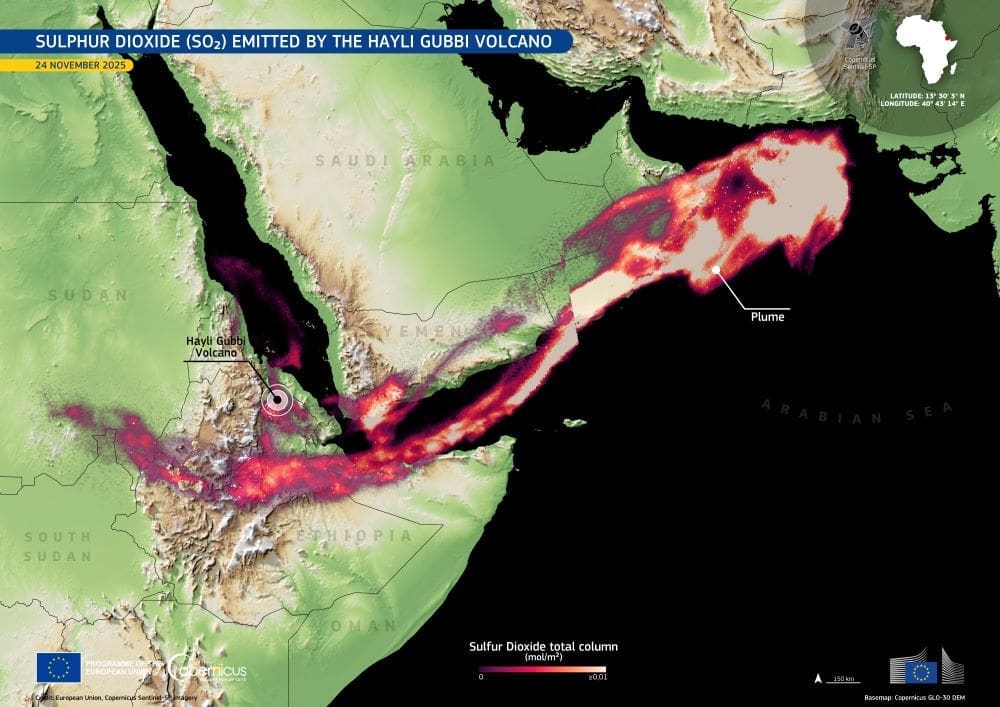
The sulfur dioxide plume from Ethiopia’s Hayli Gubbi eruption is captured in a Copernicus Sentinel-5P image that shows how a rare volcanic event sent emissions thousands of kilometres across the region. Hayli Gubbi, located about 800 kilometres north-east of Addis Ababa in Ethiopia’s Afar region, erupted on 23 November 2025 after nearly 12,000 years without known activity. The eruption marked the first recorded explosive event at this volcano and produced both high-altitude ash and substantial sulfur dioxide.
Satellite data detected the ash plume at around 11:30 on 23 November, rising quickly to 13.7 km and later reaching 15.2 km. Residents reported hearing a loud sound and feeling a shock wave, and an explosion was heard 50 km from Semera, which is 190 km south of the volcano. By about 14:00, satellite observations showed the plume containing approximately 220,000 tons of sulfur dioxide (SO₂).
Imagery revealed the higher ash drifting ENE, while a lower cloud of pyroclastic material moved north for around 130 km and spread about 60 km across the terrain. Photos published in news reports showed ash rising from flat ground some distance from the crater, consistent with dilute pyroclastic density currents. Villages across the region, including Afdera 28 km west of the volcano, were covered in ashfall, though no deaths were reported. Flight cancellations and diversions occurred across multiple countries.

The Copernicus Sentinel-5P image from 24 November shows the sulfur dioxide plume extending for roughly 3,700 kilometres from Ethiopia to the Arabian Sea. The satellite’s TROPOMI instrument supports three environmental themes: air quality, the stratospheric ozone layer, and climate change monitoring and forecasting. These measurements are essential for tracking volcanic emissions, assessing their distribution, and understanding their effects on aviation and regional air quality.
As the eruption progressed, the Toulouse Volcanic Ash Advisory Centre reported a large ash and sulfur dioxide cloud over Yemen and Oman shortly after midnight on 24 November. By late morning, the plume had moved between Oman and Pakistan at altitudes of 7.6–13.7 km. Later in the day, a broad ash cloud spread east across southern Pakistan and northeastern India, with the plume continuing toward China. By evening, ash was detected over Delhi, more than 4,000 kilometres north-east of the volcano. India experienced significant flight disruptions on 25 November as the cloud passed over major transport corridors.
The November eruption followed months of activity within the rift system. According to the UK Centre for Observation and Modelling of Earthquakes, Volcanoes and Tectonics, explosive activity at Erta Ale in July 2025 was accompanied by a dike intrusion that propagated toward Hayli Gubbi. Sentinel imagery from July showed fissure vents outside the southern caldera of Erta Ale and additional vents located only 2 km from Hayli Gubbi’s crater. Uplift across the area was recorded between late July and early August, and an anomalous white cloud was seen within the crater starting in late July. Satellite images showed the plume covering the crater floor in most observations through mid-November, indicating ongoing internal activity before the eruption.
The Copernicus data provide a detailed record of a rare volcanic episode in the Afar Rift, showing how emissions from a remote volcano travelled across multiple regions and influenced conditions far from their source.
Featured image credit: European Union, Copernicus Sentinel-5P imagery


