Snow blanketed north-east Scotland on 18 November 2025 as a strong early-season storm moved across Aberdeenshire and surrounding upland areas. Heavy snowfall arrived rapidly, transforming the landscape and creating severe disruption for communities across the region. More than 90 schools closed as conditions deteriorated, and emergency services assisted residents affected by blocked roads, stranded vehicles, and power outages. Authorities urged the public to avoid non-essential travel while teams worked to clear routes and respond to weather-related incidents.
Snowfall varied across the region, with upland terrain experiencing deeper accumulation and persistent drifting. Reports of thundersnow accompanied some of the heaviest bursts, with lightning detected along parts of the north-east coast. Rural areas recorded some of the lowest temperatures of the season so far, adding to the challenges faced by transport crews and households dealing with the effects of the storm.

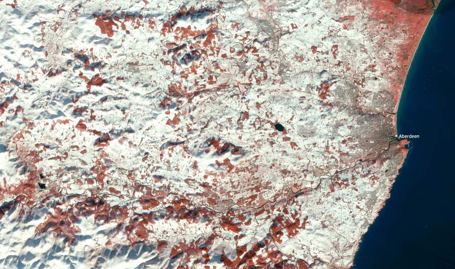
This false-colour image, captured by a Copernicus Sentinel-2 satellite on 22 November 2025, shows the broad sweep of snow across Aberdeenshire. The city of Aberdeen appears along the coastline, contrasting with the brighter tones of the surrounding snow-covered countryside. Inland areas reveal the most extensive accumulation, where higher elevations and open landscapes allowed the snow to settle and persist. The multispectral view highlights the structure of the snowpack and its extent across fields, hills, and river valleys.
Satellite data offers a clear view of the scale of the storm and helps track how snow accumulates across varied terrain. Sentinel-2 observations enable continuous monitoring of winter conditions and provide detailed information on changing surface characteristics after major weather events. Snow coverage in regions like north-east Scotland can shift quickly due to wind, temperature changes, and topography, and such imagery supports local authorities, infrastructure managers, and emergency planners working to understand how early-winter storms develop and how they affect transport networks and isolated communities.
Meteorological agencies noted that this episode formed part of a UK-wide cold wave that followed a rapid drop in temperatures and brought heavy snow and disruptions across several regions. That broader context helps explain why local officials issued amber warnings and mobilised emergency responses across northern Scotland.
Featured image credit: European Union, Copernicus Sentinel-2 imagery


