Flooding spread across central Portugal in early February 2026 as Storm Leonardo delivered days of persistent rainfall onto landscapes already saturated by previous storms. Storm Leonardo did not arrive in isolation. In the final days of January and the very beginning of February 2026, Storm Kristin had already crossed Portugal, delivering heavy rainfall that left soils saturated and river levels elevated.
When Leonardo’s persistent rain set in from 3 February onward, much of the landscape was no longer able to absorb additional water. This preconditioning meant runoff increased rapidly, pushing rivers such as the Tagus beyond their banks and allowing floodwaters to spread quickly across low-lying areas of central Portugal.
Several river basins responded sharply, including the Tagus system, where water levels climbed well beyond seasonal norms. The flooding disrupted agriculture, transport, and daily activity in communities regularly situated near riverbanks and estuarine wetlands. Emergency services were stretched as authorities worked to monitor river levels, close vulnerable roads, and assist residents in affected towns.
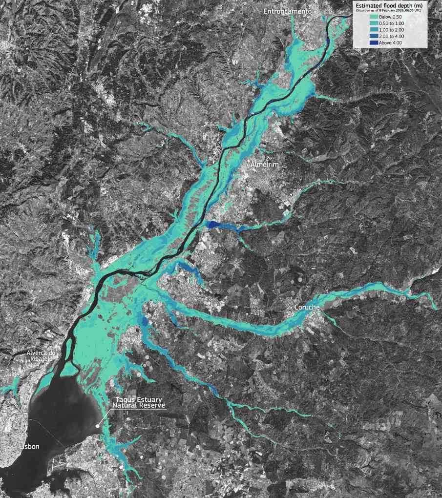
The scale of the event prompted the activation of the Copernicus Emergency Management Service Rapid Mapping module (EMSR864), tasked with assessing flood extent and potential damage across 17 Areas of Interest in Portugal. A Copernicus data visualisation based on the delineation product shows extensive flooded areas around the Tagus River and within the Tagus Estuary Natural Reserve, northeast of Lisbon. In Area of Interest 03, centred on Salvaterra de Magos, more than 64,000 hectares were mapped as flooded as of 8 February 2026.

These mapped flood extents underline how prolonged winter rainfall can transform river valleys into temporary inland seas. Agricultural land within the Tagus floodplain is particularly exposed, and while seasonal inundation is not unusual, the breadth of flooding observed during Leonardo reflects the cumulative effect of successive storms rather than a single rainfall episode.
According to Copernicus, the mapping supports authorities by providing geospatial information that helps monitor extreme weather events and assess their impacts. Such data are used to guide emergency response, prioritise affected areas, and document the evolving situation as water levels change.
While Storm Leonardo’s heaviest rainfall eased later in the week, the ground and river systems remained saturated. As Leonardo’s impacts lingered, another Atlantic system, Storm Marta, approached Iberia by Saturday, bringing fresh rainfall and strong winds to already affected areas. The extent to which Marta added to the flooding mapped by Leonardo has not yet been fully assessed, but authorities remained on high alert as rivers and low-lying areas continued to be monitored.
Featured image credit: European Union, Copernicus Emergency Management Service


