The Ebro River surge in Aragón in February 2026 has pushed winter flows beyond 1,000 m³ per second through Zaragoza, with forecasts indicating a peak near 1,600 m³ per second as the flood wave moved downstream. While classified as an ordinary seasonal rise by basin authorities, the event has been strong enough to inundate farmland, close rural tracks and prompt precautionary measures along the Ribera del Ebro.
In Novillas, upstream of Zaragoza, water levels reached 7.55 m during the first peak, affecting low-lying agricultural zones built into the river’s natural floodplain. The episode illustrates how sustained rainfall across the upper basin translates into delayed but concentrated flow increases many kilometres downstream.
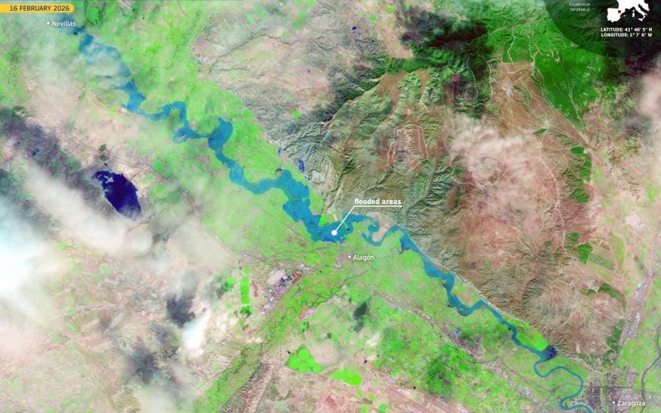
This false-colour image, acquired by one of the Copernicus Sentinel-2 satellites on 16 February 2026, shows the Ebro upstream of Zaragoza. The riverbed and flooded areas along its course appear in blue tones. Novillas, visible in the upper left of the image, was among the first municipalities affected by the flood peak, during which water levels rose to 7.55 metres.
Zaragoza’s Municipal Emergency Plan was activated as a precaution, though no significant urban damage had been reported. The city’s river parks and designated overflow areas are designed to accommodate rises of this scale, reducing pressure on densely populated districts.
Although not an extreme flood by historical standards, flows of this magnitude remain operationally significant. They test embankments, agricultural infrastructure and local response systems, particularly in winter when soils are saturated. Satellite monitoring allows authorities to track the spread of water across the floodplain in near real time, supporting decisions on road closures, farm access and downstream preparedness.
Copernicus data support authorities in monitoring river dynamics, assessing impacts, and guiding flood risk management along major European waterways.
Featured image credit: European Union, Copernicus Sentinel-2 imagery

