Western Queensland is underwater after record-breaking rainfall in late March 2025 triggered the region’s worst flooding in 50 years. Entire communities have been cut off, roads submerged, and farmland devastated as rivers swelled beyond their banks. Some areas received over 600 millimeters of rain — nearly twice their annual average — in just a few days, forcing evacuations and leaving emergency crews scrambling to provide aid.
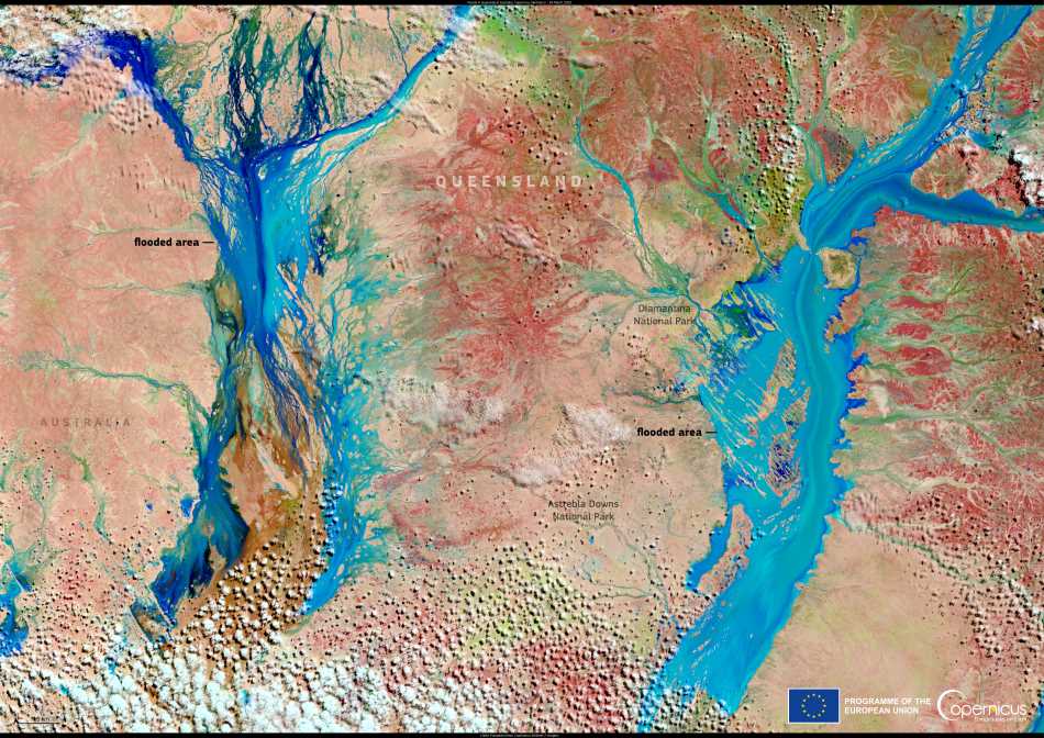
This Copernicus Sentinel-2 image, captured on 29 March 2025, shows the extent of the flooding near Diamantina and Astrebla Downs National Parks. The vast swathes of water, seen in blue, highlight the scale of the disaster.

Satellite imagery like this plays a crucial role in tracking flood progression, helping officials make informed decisions on disaster response and recovery efforts.
As floodwaters move downstream, authorities warn the crisis is far from over. Some towns — Jundah, Stonehenge, and Windorah — are seeing water levels surpass even the infamous 1974 floods. With more rain in the forecast, concerns are growing over the long-term impact on agriculture, with potentially hundreds of thousands of livestock lost.
This is just the latest in a series of extreme weather events battering Queensland this year. In early March, Tropical Storm Alfred lashed the state’s east coast, leaving hundreds of thousands without power. Earlier in the year, torrential rains flooded a 735-kilometer stretch of northern Queensland, killing at least one person and forcing mass evacuations.
Scientists warn that as global temperatures continue to rise, extreme rainfall events like this will become more frequent and intense, putting communities at even greater risk. For now, residents across Queensland can only wait and hope that the worst is behind them.
Featured image credit: European Union, Copernicus Sentinel-2 imagery


