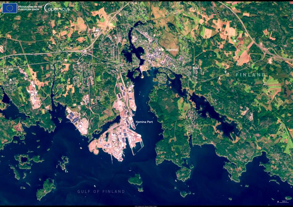
From its historic circular town center to its modern industrial infrastructure, Hamina blends tradition and trade along Finland’s southern coast. Captured in a satellite image taken on 5 September 2024 by one of the Copernicus Sentinel-2 satellites, the view reveals the unique geometry of the fortress town of Hamina and the nearby Hamina Port — Finland’s primary hub for the wood processing industry.
The port lies just east of the town and plays a central role in the nation’s export economy. With a concession area covering over 240,000 square meters, Hamina Port handles a significant share of the country’s timber products. It forms part of the larger Port of HaminaKotka, which spans more than 1,100 hectares along the Gulf of Finland and serves as a key logistical node for Finnish industry. Together, these ports support extensive cargo operations, offering deep-water access, rail connections, and intermodal facilities essential for northern Europe’s trade routes.

The image also highlights Hamina’s historical roots, visible in the concentric street pattern that surrounds the town hall at its core — a layout originally designed in the 18th century to function as a military garrison. Today, while the fortress character endures in the town’s layout, the area has expanded into a modern hub for forestry-based exports, backed by advanced port logistics.
The Copernicus Sentinel-2 mission, operated by the European Space Agency, routinely captures such imagery to support environmental and commercial monitoring. Its optical instruments deliver high-resolution images that are invaluable for maritime oversight, land use tracking, and emergency response. For coastal infrastructure like Hamina Port, this satellite data helps monitor ship movements, assess changes in land or sea conditions, and plan future expansions with minimal environmental disruption.
As the demand for sustainable forestry products grows, ports like Hamina are set to play an even greater role in Europe’s circular economy. Satellite imagery not only documents their current footprint but also helps guide decisions for safer, smarter maritime transport.
This image stands as a reminder of how old-world town planning and modern trade infrastructure coexist on Finland’s coast — interconnected by both rail lines and satellite signals.
Featured image credit: European Union, Copernicus Sentinel-2 imagery


