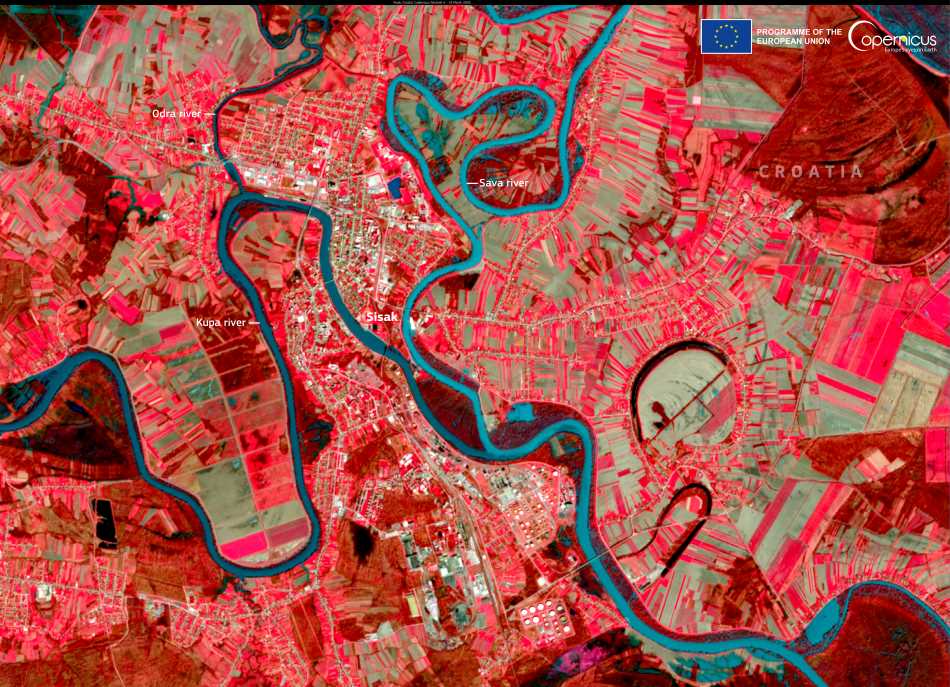
Seen from above, the Croatian city of Sisak appears as a quiet patchwork of streets, bridges, and greenery, nestled between the curves of three converging rivers. But this modest appearance belies a history that stretches back thousands of years. Captured on 19 March 2025 by one of the Copernicus Sentinel-2 satellites, this image reveals Sisak’s defining feature – its geography. Located where the Kupa, Sava, and Odra rivers meet, the city has long been shaped by water, trade, and strategic power.
Sisak sits in the heart of Sisak-Moslavina County, a region steeped in history and resilience. Known as one of Croatia’s oldest continuously inhabited settlements, Sisak’s roots extend to the Iron Age. It was once a major Roman stronghold called Siscia, playing a critical role in the empire’s defense and commerce. Today, remnants of Roman walls and artifacts remain visible across the city, offering a tangible link to the past.

The legacy of Sisak did not end with the Romans. In the medieval period, the city was fortified with a striking star-shaped fortress, still intact today, constructed to defend against Ottoman advances. In the 19th century, Sisak emerged as one of the first industrial centers in the region, thanks to its position on navigable rivers and its proximity to natural resources. Traces of that era remain in the form of red-brick warehouses, industrial chimneys, and a now-quiet oil refinery, all visible in satellite views to the trained eye.
Sentinel-2’s image highlights more than urban features. The lush landscape of central Croatia, surrounding the city, tells another story – of a place where agriculture and river management remain vital. Seasonal flooding, a constant in this low-lying region, is one of many factors tracked by the European Union’s Copernicus programme. Through high-resolution, multispectral imagery, the Sentinel satellites help monitor changes not just in the environment, but in the preservation of cultural heritage as well.
As cities like Sisak balance historical preservation with modern demands, Earth observation missions provide crucial support. From measuring urban sprawl to identifying threats from climate and weather, satellite imagery offers a view into both the past and the future – one frame at a time.
The image featured today was acquired by the Copernicus Sentinel-2 satellite mission, part of the European Union’s Earth observation programme.
Featured image credit: European Union, Copernicus Sentinel-2 imagery


