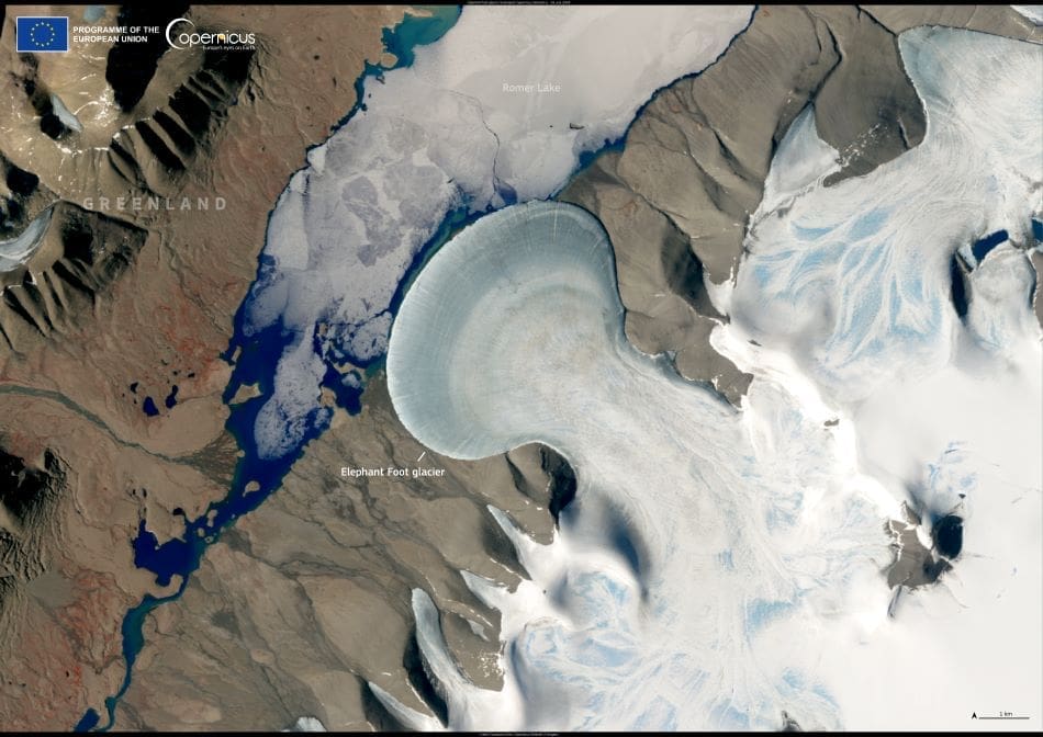
Greenland’s Elephant Foot Glacier offers one of the most visually distinctive examples of a piedmont glacier – a type of glacier that flows from a confined valley and spreads outward when it reaches flatter terrain. Located on the Kronprins Christian Land peninsula in the island’s far northeast, this glacier extends into Romer Lake, forming a near-perfect fan-shaped lobe that spans approximately 5.4 kilometres. Its remarkable shape, resembling a colossal footprint, is what earned it the name ‘Elephant Foot’.
This Copernicus Sentinel-2 image, taken on 16 July 2024, captures the glacier in midsummer, when surface melting is typically at its highest in Greenland. The image provides a clear view of the glacier’s symmetrical terminal lobe and the surrounding terrain, including the rocky landscape and meltwater lakes that form along the margins of the ice. These visual details are not only stunning but also scientifically valuable.

Monitoring glaciers like Elephant Foot has become increasingly important in the context of climate change. As temperatures rise across the Arctic, many of Greenland’s glaciers are thinning, retreating, or accelerating in flow, contributing to global sea-level rise. While Elephant Foot Glacier is relatively small compared to some of Greenland’s major ice streams, it is part of the broader cryospheric system responding to changing environmental conditions.
The Copernicus Sentinel-2 mission, part of the European Union’s Earth observation program, plays a critical role in tracking these changes. Its high-resolution optical imagery and frequent revisit time allow scientists to observe glacier movement, surface melting, and structural changes with impressive detail. The open access to this data supports researchers around the world in their efforts to document glacial dynamics and inform climate policy.
This image is a powerful reminder of both the beauty and fragility of the polar regions – and the vital role satellite technology plays in helping us understand how these remote landscapes are evolving.
Featured image credit: European Union, Copernicus Sentinel-2 imagery


