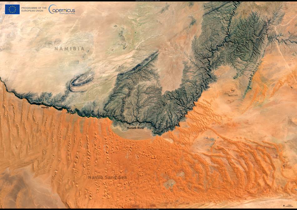
The Kuiseb River traces a dramatic line through the Namib Desert, forming a natural divide between the towering red dunes of the Namib Sand Sea to the south and the gravel plains to the north. This ephemeral watercourse begins in the Khomas Hochland mountains near Windhoek and flows westward, typically ending in the dune fields east of Walvis Bay. Only during exceptional floods does it reach the Atlantic Ocean.
This Copernicus Sentinel-2 image, captured on 8 May 2025, highlights the stark contrasts of central Namibia’s landscapes. The riverbed is visible as a dark, vegetated corridor winding through otherwise pale, sun-scorched terrain. To the south, the Namib’s dunes are densely packed and rise sharply in elevation, while the rocky escarpments to the north show a more subdued and ancient geology.

The satellite image reveals the Kuiseb’s role as a formidable ecological boundary. The river’s seasonal floods help nourish narrow strips of woodland and scrub, providing rare habitat and resources for desert-adapted wildlife. The Kuiseb also halts the northward advance of the mobile sand dunes, a dynamic first described by German geologist Henno Martin in the 20th century. Martin and his colleague Hermann Korn famously survived two years along the river during World War II, chronicled in The Sheltering Desert.
Though often dry, the Kuiseb remains vital for both wildlife and people in the region. Flash floods can occur during Namibia’s rainy season, briefly transforming the river into a fast-flowing channel. These periodic surges recharge groundwater, sustain vegetation, and support communities in nearby settlements such as Gobabeb — a key site for desert research.
The Copernicus Sentinel missions provide critical Earth observation data that allow scientists to monitor such remote and sensitive ecosystems. Imagery from Sentinel-2 helps track changes in river patterns, dune movement, and vegetation cover, offering long-term insight into the impacts of climate variability and land use in Namibia’s arid southwest.
Featured image credit: European Union, Copernicus Sentinel-2 imagery


