Severe flooding inundated parts of central and northern Romania in late May 2025 after days of continuous rainfall overwhelmed rivers and urban drainage systems. Streets, fields, and homes were submerged across 16 counties, leading to widespread damage and the evacuation of hundreds of residents.
According to Euronews, emergency services worked around the clock as rising waters forced people from their homes in several towns and villages. The heaviest impacts were reported in areas near the Râul Negru, a tributary of the Olt River in Covasna County. Local media shared footage of flooded roads, stranded vehicles, and communities struggling to protect their properties with sandbags.

On 28 May, Romania’s Inspectorate General for Emergency Situations (IGSU) requested assistance from the Copernicus Emergency Management Service (CEMS) to assess the situation from space. The service quickly activated EMSR802 for flood mapping in the region.
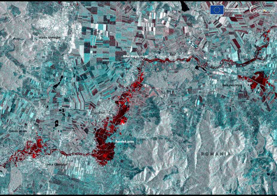
This Copernicus Sentinel-1 satellite image, acquired on 29 May 2025, shows the extent of flooding around the towns of Ozun, Dobolii de Jos, Lunca Câlnicului, and Boroșneu Mare. Dark areas visible in the radar image correspond to surface water, revealing how floodwaters spilled across farmlands and low-lying areas near the riverbanks.
The data provided by the Copernicus programme plays a crucial role in supporting emergency response and post-disaster recovery. By mapping flood extents with high accuracy, the satellite imagery allows authorities to prioritize aid delivery, evaluate infrastructure damage, and plan for long-term mitigation.
As extreme weather patterns become more frequent, open satellite data is becoming an essential tool for managing climate-related risks. In Romania, the rapid deployment of space-based monitoring helped local agencies better understand the scale of the disaster and coordinate relief efforts.
Featured image credit: European Union, Copernicus Sentinel-1 imagery


