In the southern reaches of the Cape Verde archipelago, the island of Fogo rises from the Atlantic with a stark, volcanic presence. At its core stands Pico do Fogo – “peak of fire” – an active stratovolcano that reaches nearly 2,830 metres, making it the highest point in Cape Verde. The island takes its name from this mountain, and its terrain, culture, and way of life have been shaped by centuries of eruptions and adaptation.
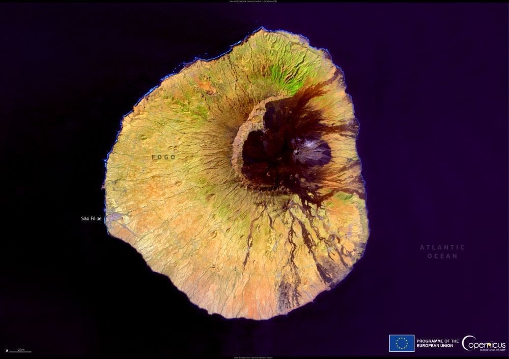
This Copernicus Sentinel-2 image, captured on 24 February 2025, reveals Fogo’s dramatic contours, from the collapsed caldera of Chã das Caldeiras to the black lava flows radiating from its summit. The crater spans about 8 kilometres and sits at 1,600 metres above sea level, still volcanically active and home to two small villages, Portela and Bangaeira. These settlements were devastated by the most recent eruption in 2014 but have since been partly rebuilt. Residents live without public electricity or running water, cultivating vineyards and producing a distinctive local wine on the fertile volcanic soil.

To the southwest, São Filipe perches on a 100-metre cliff above the ocean. As the island’s capital and oldest town, it is known for its preserved Portuguese colonial houses and its views of a wide, black-sand beach below. São Filipe hosts an annual cultural festival in early May and connects to the rest of the archipelago via a small airport and ferry routes.
Fogo’s eastern and northern slopes are greener, fed by trade winds and dotted with small farming communities like Mosteiros and Cova Figueira. Trekking trails across the island follow ancient lava rivers and ash fields, offering a closer view of the volcanic forces that define life here. Ascending Pico do Fogo takes three to four hours and a climb of over 1,000 metres, often through steep scree, requiring experienced guides and sturdy shoes.
Copernicus Sentinel satellite data supports the monitoring of islands like Fogo, helping local authorities track volcanic activity, coastal erosion, and land use. These open data tools provide critical information for environmental management and resilience in remote island communities.
Featured image credit: European Union, Copernicus Sentinel-2 imagery


