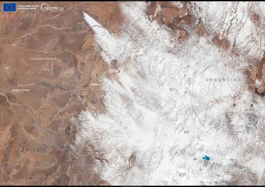
Snowfall in the Atacama Desert is so uncommon that when it does occur, it transforms one of Earth’s driest landscapes into an unfamiliar scene. On 26 June 2025, such a transformation occurred when snow fell across parts of the Atacama, covering observatory equipment and desert terrain in white.
This rare weather event affected the Chilean altiplano and was especially visible at the Operations Support Centre of the ALMA Observatory, situated at 2,900 metres above sea level. Located over 1,700 kilometers north of Santiago, ALMA – short for Atacama Large Millimeter/submillimeter Array – is a major astronomical facility operated in partnership by institutions from Europe, the United States, and Japan. Its high-altitude location was chosen specifically for its dry, stable atmosphere, making the recent snow even more exceptional.
The Copernicus Sentinel-2 image, captured on the same day, reveals fresh snow in the Atacama Desert region of northern Chile, as well as across the Andes into Argentina. Snowfall of this kind is highly unusual and hadn’t been observed at this intensity in over a decade. Copernicus satellite data, freely available through the EU’s Earth observation program, supports ongoing efforts to monitor snow cover globally, contributing to safer operations in remote or high-risk environments.

According to local reports, temperatures during the night dropped below –12 °C, with wind chill reaching –28 °C. In response, ALMA’s staff activated its “survival mode” protocol – designed to protect sensitive instruments during extreme weather. The observatory’s antennas were repositioned to face the wind more securely, and social media posts from ALMA later showed snow surrounding both the support buildings and the antenna array on the Chajnantor Plateau.
While snowfall can occasionally occur in the highest parts of the desert, this level of coverage at the support facilities is a rarity. The Atacama’s unique dryness – explained in part by its geography and atmospheric conditions – makes it a global benchmark for aridity. The region receives only a few millimeters of precipitation each year, and entire weather systems can pass overhead without delivering moisture.
Such a snow event, though brief, highlights the climatic extremes possible even in the driest places on Earth.
Featured image credit: European Union, Copernicus Sentinel-2 imagery


