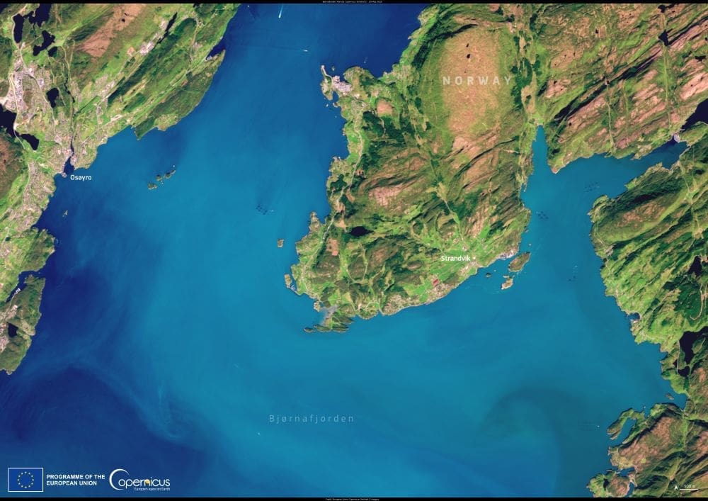
Bjørnafjorden, Norway’s widest fjord, cuts deep into the coastline of Vestland county, stretching around 30 kilometers long and up to 10 kilometers wide. Formed by ancient glaciers, the fjord reaches depths of nearly 600 meters and spans the municipalities of Bjørnafjorden, Austevoll, and Tysnes. The name means “Bear Fjord” in Norwegian, possibly referencing the region’s once-prevalent wildlife or the shape of the landscape.
This cloud-free image, acquired on 20 May 2025 by a Copernicus Sentinel-2 satellite, shows part of the fjord from above, capturing the dramatic contrast between the deep blue waters and the steep, forested hillsides. The administrative center of Bjørnafjorden municipality, Osøyro, is visible in the upper section of the image, while the smaller coastal village of Strandvik appears on the eastern shoreline.

Bjørnafjorden municipality was established in 2020 through the merger of the former Os and Fusa municipalities. It covers 517 square kilometers, with a population of around 25,600 as of 2023. Osøyro, the largest town, is home to over 15,000 people and serves as the area’s commercial and transport hub. The community is connected to Bergen and surrounding regions by the E39 highway and ferry routes across the fjord.
The surrounding landscape is popular with hikers, campers, and nature enthusiasts. Trails vary from coastal paths to more strenuous climbs with views over the fjord. The area is also known for water sports, including kayaking, diving, and fishing. Inland, lakes such as Skogseidvatnet and Gjønavatnet attract visitors to the Hålandsdal valley, offering quiet spots for recreation and exploration.
The Sentinel-2 image is part of the Copernicus Earth observation programme, which provides free and open data to support sustainable development, biodiversity monitoring, and environmental management worldwide. Coastal fjord regions like Bjørnafjorden are especially valuable for studying how climate change affects marine ecosystems, land use, and human settlements.
Featured image credit: European Union, Copernicus Sentinel-2 imagery


