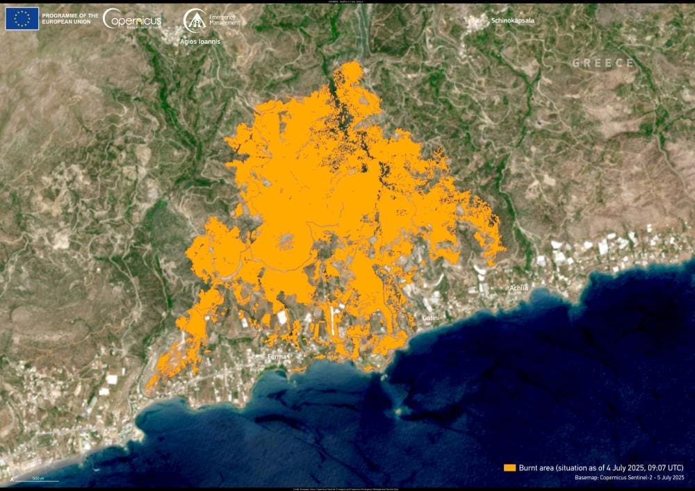
Thousands of residents and tourists have been forced to flee homes and hotels after a major wildfire started burning across eastern Crete. The blaze began near the village of Achlia on 2 July 2025 and has rapidly advanced across mountainous terrain, fanned by gale-force winds and extreme heat.
Greece’s fire service reports that the wildfire has split into three active fronts – in Achlia, Ferma, and Skinokapsala – complicating efforts to contain the flames. Authorities say strong winds are creating dangerous flare-ups and spreading the fire toward both coastal and inland communities.
Evacuation orders have been issued for homes, rental properties, and hotels across the Ferma municipality. “Around 5,000 people have been evacuated, the majority of whom are foreign tourists staying in local hotels,” Manolis Tzarakis, president of the Ierapetra and Southeast Crete Hoteliers’ Association, told a local radio station on Thursday (3 July 2025), . At least 200 evacuees were sheltered in a sports hall in the nearby town of Ierapetra.

As of Thursday morning, 230 firefighters had been deployed to the area, supported by 13 specialised foot teams, 46 fire engines, drone surveillance, and ten helicopters. Damage is reported across a wide area, including destroyed homes, greenhouses, villas, hotels, and businesses. In Agia Fotia, properties have been lost and a power outage is ongoing, according to local reports.
To support emergency operations, the Copernicus Emergency Management Service (CEMS) was activated on 3 July by Greece’s Disaster Planning and Management Directorate. The satellite image above was captured on 4 July 2025 at 09:07 UTC and processed through CEMS On-Demand Rapid Mapping service (EMSR809). It shows the wildfire-affected area in eastern Crete, with burn scars clearly visible. This high-resolution data provides emergency teams with crucial information for assessing the scale of destruction and planning their response.
The open-access data provided by Copernicus Sentinel satellites plays a vital role in tracking wildfire activity across Europe. Satellite imagery supports civil protection efforts by helping identify active fire fronts, monitor damage, and coordinate evacuations more effectively.
Featured image credit: European Union, Copernicus Emergency Management Service


