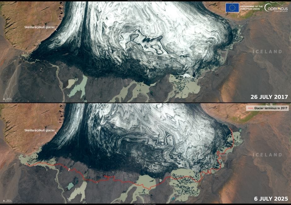
The Skeiðarárjökull glacier in southern Iceland is visibly retreating, as shown in Copernicus Sentinel-2 satellite images captured on 26 July 2017 and 6 July 2025. In the latest image, the 2017 terminus is outlined in red, making the change unmistakable. This outlet glacier of Vatnajökull – Europe’s largest ice cap by volume – has long been shaped by the interplay between fire and ice, with volcanic activity and glacial forces continuously reshaping the region.
Stretching around 75 kilometres from the highlands down to just 100 metres above sea level, Skeiðarárjökull channels ice from the heart of Vatnajökull toward the lowlands. As it melts, it feeds several rivers, including the short but volatile Skeiðará, which has been known for dramatic glacial outburst floods – jökulhlaups – that reshape the land and threaten infrastructure.

The most destructive of these occurred in 1996, when the Gjálp subglacial eruption triggered a torrent of meltwater. With flow rates peaking at 45,000 cubic metres per second, the flood tore through the Skeiðará River valley, damaging the 880-metre-long bridge on Iceland’s Ring Road. Massive icebergs carried downstream caused severe damage, although no lives were lost thanks to early warnings based on close volcanic monitoring.
This region, marked by Skeiðarársandur’s black outwash plains, continues to evolve as glaciers recede. The Skeiðarársandur landscape – formed by centuries of flood-deposited sediment – stretches 40 kilometres across, bearing witness to the volatile history of glacial and volcanic activity.
The Copernicus Sentinel-2 images, which offer consistent, high-resolution data, are essential for tracking changes to glaciers like Skeiðarárjökull. With climate shifts accelerating ice loss worldwide, such satellite data remains vital for understanding and preparing for the environmental consequences ahead.
Featured image credit: European Union, Copernicus Sentinel-2 imagery


