A severe wildfire broke out in Greece’s Northern Peloponnese region on the afternoon of 22 July 2025, consuming pine-covered slopes and threatening multiple rural communities. The blaze ignited near the village of Kastania in Corinthia at 13:20 UTC, spreading rapidly through a densely forested and mountainous area known for its ecological significance. Driven by extreme heat and dry winds, the fire prompted widespread evacuations and a large-scale emergency response.
Greek authorities deployed 340 firefighters supported by 15 ground teams, municipal water trucks, and earth-moving equipment. Aerial support included 11 aircraft and 10 helicopters. Despite the difficult terrain, crews worked overnight to contain the flames. While the fire has since been brought under control, emergency services remain in the area on high alert for potential flare-ups, which are common following large-scale wildfires.

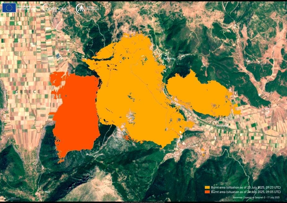
The image above, produced by the Copernicus Emergency Management Service (CEMS), visualizes the evolution of the fire-affected area between 23 and 24 July. Based on satellite data gathered during EMSR815 – the emergency mapping activation requested by Greek authorities – the map highlights burned zones and potential damage to infrastructure. According to CEMS analysis, approximately 1,578.9 hectares of land were scorched, along with 22.8 km of roads and 4.5 hectares of built structures potentially affected. The first mapping product was delivered just 20 hours after the initial activation.
The fire struck during a period of heightened national alert, with Greek Civil Protection warning of extreme fire danger across several regions, including the Peloponnese. Forecasts predicted inland temperatures exceeding 41 °C, part of a broader heatwave that had already placed much of the country under red warnings. The European Forest Fire Information System (EFFIS) classified fire danger in Corinthia as “extreme” at the time of the blaze.
Among the hardest-hit locations were the villages of Kastania, Kionia, Stymfalia, Matziza, Drosopigi, and Kasteri, where evacuations were ordered as the fire approached. The destruction of dense pine and fir forests in Feneos – an area valued for both its natural beauty and biodiversity – represents a major ecological loss. Local communities also faced direct damage, with reports confirming the loss of homes in Kastania.
The Corinthia fire came just weeks after another large-scale wildfire ravaged the island of Chios in late June, where over 10,000 acres were lost and a state of emergency declared. Authorities launched a criminal investigation following reports that the Chios fire began in multiple locations, raising the possibility of arson.
As the climate crisis intensifies wildfire conditions across southern Europe, satellite-based monitoring services like Copernicus have become essential for tracking fire progression and informing disaster response. The open data provided by Sentinel satellites enables real-time assessments that support national emergency efforts and post-fire recovery planning.
Featured image credit: European Union, Copernicus Emergency Management Service


