Southern Cyprus is reeling from a catastrophic wildfire that broke out on 23 July near the villages of Malia and Souni, west of Limassol. The fire has claimed at least two lives, injured several others, destroyed dozens of homes, and forced mass evacuations across the region. Officials estimate that more than 100 square kilometres of forest, agricultural land, and rural infrastructure have been consumed, in what is shaping up to be one of the most damaging wildfires in Cyprus in recent memory.
The blaze erupted during a prolonged heatwave, with temperatures reaching 43 °C and strong, dry winds fanning the flames across the hilly countryside. The fire’s rapid expansion prompted authorities to evacuate at least 11 villages, including Vouni, Lofou, Omodos, Koilani, Arsos, and Potamiou. Many of these communities lie in the island’s main wine-producing region, where vineyards, orchards, and pine-covered slopes have suffered extensive damage.
One of the most harrowing moments occurred in Lofou, where 36 people became trapped aboard a bus as flames approached. The group was eventually escorted out by police and National Guard forces. Meanwhile, in the area between Monagri and Alassa, two people were found dead in a burned-out vehicle, bringing the human toll into sharp focus.
Emergency services have deployed more than 250 firefighters, supported by 75 fire engines and up to 14 aircraft, including water bombers from Greece, Jordan, Spain, Lebanon, Israel, and the UK. Despite their efforts, shifting winds and record-breaking temperatures have complicated containment. Investigators suspect arson, pointing to multiple ignition points and early witness accounts, though the cause remains officially undetermined.

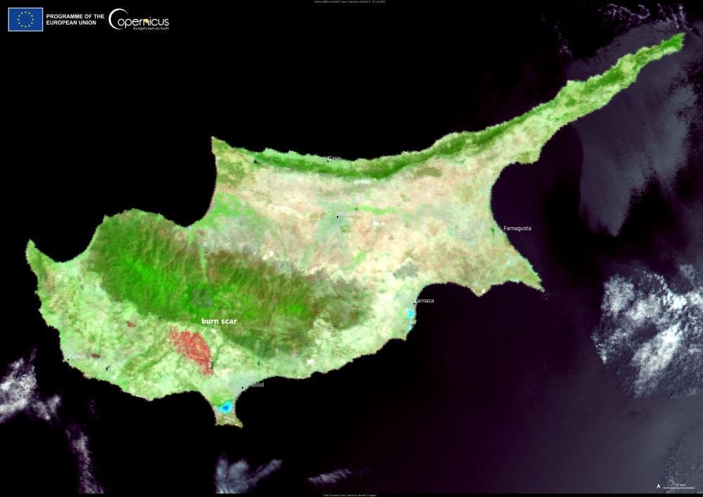
The satellite image above illustrates the scale of the destruction. Captured two days after the fire broke out, it shows a wide swath of scorched land in the Limassol district, with the red areas highlighting the burn zone. Such imagery is crucial not only for assessing immediate damage but also for coordinating response efforts, monitoring post-fire conditions, and planning long-term environmental recovery.
In total, the blaze has destroyed at least 32 homes, heavily damaged 53 others, and burned dozens of vehicles. A small chapel in Vouni was reduced to rubble, and widespread power outages affected the area as over 300 electricity poles, 30 transformers, and one substation were damaged. The nearby Kouris reservoir, the country’s largest, is currently at just 15.5% capacity after three consecutive dry winters – a stark reminder of how climate pressures and infrastructure vulnerability compound disaster risks.
Local residents have expressed frustration over perceived delays in the emergency response. Some said they received no warning before smoke and flames reached their doorsteps. Others credited neighbours and community networks for helping save lives. The government has pledged support for rebuilding and relief and has requested assistance through the EU Civil Protection Mechanism.
As the fire is gradually brought under control, authorities are assessing the long-term impact on the region’s agriculture and ecosystems. The blackened landscape will require months – if not years – of recovery. And while the flames may be retreating, the broader consequences of rising temperatures, prolonged drought, and increasing fire risk across the Mediterranean remain in plain view.
Featured image credit: European Union, Copernicus Sentinel-3 imagery


