A wildfire that broke out on 26 July 2025 in central Kythira has scorched forested land near the village of Pitsinades, triggering evacuations and a major emergency response. The island, part of Greece’s Attica region and one of the seven main Ionian Islands, faced rapidly spreading flames driven by dry summer conditions and wind.
Authorities mobilised a wide-scale firefighting operation, including 28 firefighters, a specialised EMODE forest unit, six fire engines, local volunteers, and support from one helicopter and two firefighting aircraft. Seven more firefighters from the 6th EMODE unit were transported by ferry from Neapoli in the southern Peloponnese. While there were no initial reports of injuries or property loss, the fire’s spread prompted multiple evacuation alerts across the area.

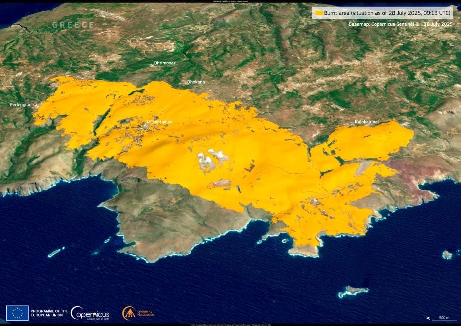
The Ministry of Climate Change and Civil Protection activated the Copernicus Emergency Management Service (CEMS) on the day the fire started, requesting rapid satellite mapping to assess the evolving threat. Based on two remotely sensed images, Copernicus EMS estimated that 2,812.2 hectares of land had burned by 28 July. The mapped area also showed that approximately 56.1 km of roads and 21.8 hectares of built-up areas may have been affected.
This visualisation, produced through CEMS emergency mapping (EMSR818), shows the fire’s extent as of 28 July and supports the ongoing emergency response. The activation remains live, with data updates continuing as the situation develops.
The open data provided by the Copernicus Sentinel satellites and services is essential for monitoring wildfires in near real time and mapping their impacts with precision – a critical tool for civil protection teams across Europe.
Featured image credit: European Union, Copernicus Emergency Management Service


