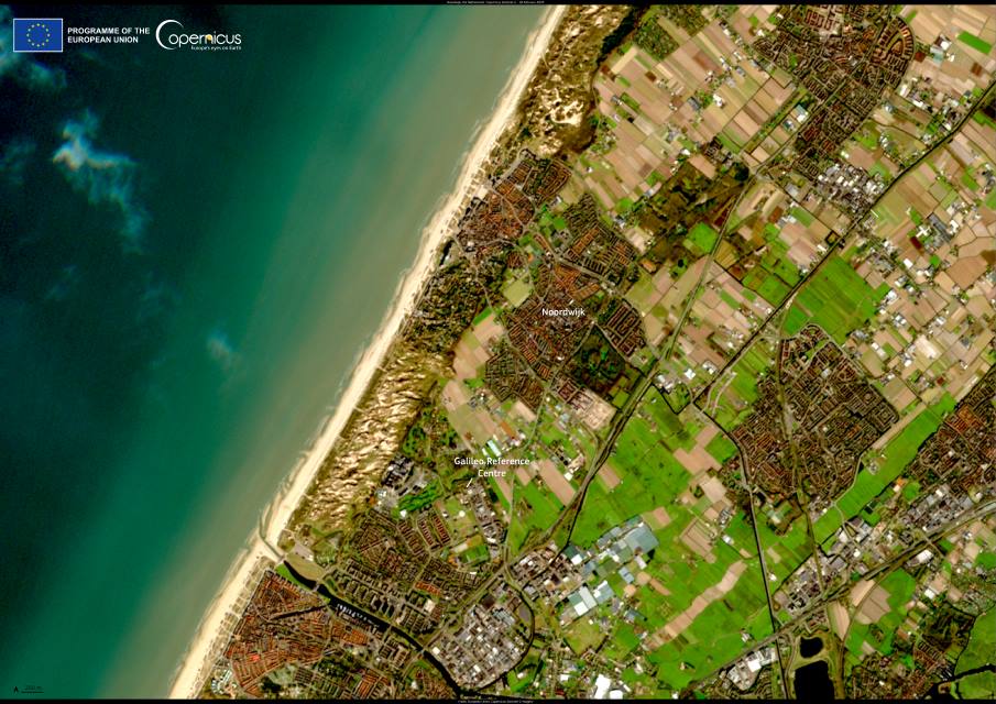
Noordwijk, on the Dutch North Sea coast, combines natural beauty with a growing role in European space activity. The town is known for its 13 kilometres of sandy beaches, tall dunes, and pine forests that form part of a Natura 2000 reserve north of the city. These protected landscapes are home to deer and a wide variety of flora and fauna, drawing walkers, cyclists, and horse riders. The dunes also host the Kennemer Zweefvlieg Club, one of the country’s oldest gliding associations.
Alongside its seaside character, Noordwijk is also a hub for the European Union Space Programme. The Galileo Reference Centre (GRC), based here, is a cornerstone of the Galileo system, Europe’s global navigation satellite network. Operated by the European Union Agency for the Space Programme (EUSPA), the facility provides independent monitoring of Galileo’s performance and ensures the system delivers accurate and reliable services to users around the world.

This image, captured by the Copernicus Sentinel-2 mission on 18 February 2025, shows Noordwijk and the Galileo Reference Centre set within the town’s coastal surroundings.
The GRC consists of a core facility in Noordwijk and contributions from EU member states, Norway, Switzerland, and Iceland. From its base, the centre assesses service quality, investigates degradations, conducts dedicated analyses, and archives performance data. Cooperative entities supply monitoring data, laser ranging campaigns, and field tests involving cars, vessels, aircraft, and drones, helping to strengthen Galileo’s reliability.
The centre’s work supports the EU GNSS monitoring system. Reports generated in Noordwijk are used by EASA to assess aviation safety compliance and by EUROCONTROL to evaluate operational impacts on air traffic management. Beyond Europe, the GRC plays a role in United Nations projects on compatibility and interoperability between Galileo and other global navigation systems, including GPS, GLONASS, and BeiDou.
Featured image credit: European Union, Copernicus Sentinel-2 imagery


