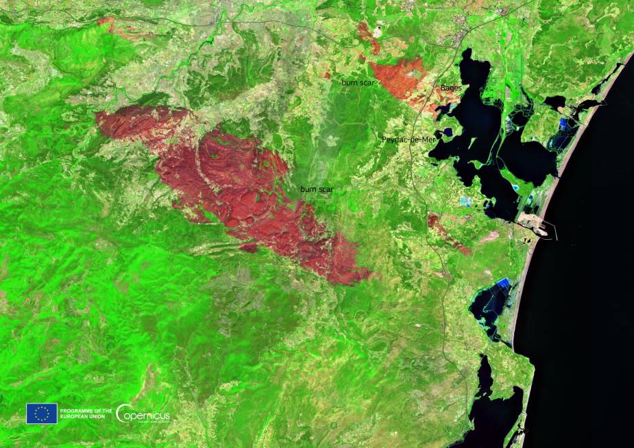
A wildfire that erupted on 5 August 2025 in the Corbières massif of southern France left a vast burn scar across the Aude region, now visible from space. The blaze consumed more than 17,000 hectares – an area larger than Paris – making it the most destructive wildfire in France in nearly 80 years.
Severe drought, parched vegetation, and the Tramontane wind drove the fire’s rapid spread through pine forests, scrubland, and vineyards. At its peak, flames threatened 15 villages and forced mass evacuations. Authorities reported one death, a seriously injured victim, and 19 firefighters hurt while battling the blaze. Dozens of houses were destroyed, while nearly 900 hectares of vineyards were lost, with hundreds more damaged by extreme heat.

By 7 August, firefighters had succeeded in fixing the fire, though it was not yet fully extinguished. At the height of the emergency, about 1,300 personnel were deployed to secure nearly 90 kilometers of fire lines and to prevent flare-ups in the scorching conditions. Evacuated residents began returning to their homes from 8 August onward, though officials warned that complete extinguishing would take more time.
The Copernicus Sentinel-2 satellite captured this image on 14 August, showing the scale of devastation across the Aude landscape. The red tones mark the burn scar carved by the flames, contrasting sharply with the surrounding countryside that escaped destruction.
Copernicus satellites provide near real-time monitoring of wildfires, supporting emergency services with vital data on the scale and progression of blazes. With longer and more intense fire seasons becoming a reality in France, such tools are increasingly critical for managing risks and protecting communities.
Featured image credit: European Union, Copernicus Sentinel-2 imagery


