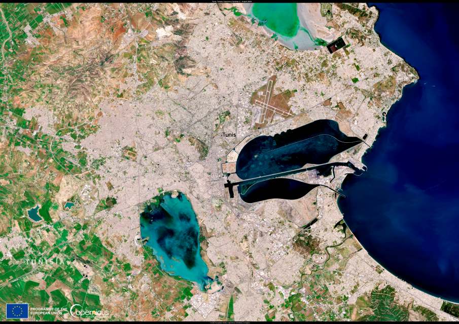
Tunis, the political and cultural heart of Tunisia, stretches across a captivating landscape where the Mediterranean Sea meets a tapestry of coastal lagoons and wetlands. At the center of this ecological mosaic lies the Lake of Tunis Complex, a brackish lagoon and intertidal marsh system designated as a Ramsar Wetland of International Importance on 23 January 2013, spanning approximately 2,243 hectares.
This site supports over 138 aquatic fauna species, provides nursery and spawning grounds for fish, and shelters wintering populations of birds like the Great Crested Grebe (Podiceps cristatus), Northern Shoveler (Anas clypeata), and over 6% of the Greater Flamingo (Phoenicopterus roseus) population in the Western Palearctic.
Another vital wetland, Sebkha Séjoumi – to the southwest of Tunisia’s capital – was designated a Ramsar site on 7 November 2007, with an area of around 30 square kilometers. Recognized as a Wetland of International Importance, an Important Bird Area (IBA), and a Key Biodiversity Area (KBA), Sebkha Séjoumi ranks among North Africa’s most significant wintering sites for waterbirds.
Every year, migratory species such as flamingos, herons, and various waders use these wetlands as essential stopovers along the East Atlantic Flyway. As they pause to feed and rest, these birds link ecosystems stretching from the Arctic to southern Africa – making Tunisia’s wetlands critical links in their long-distance journeys.

This Copernicus Sentinel-2 image, acquired on 4 April 2024, captures the intricate juxtaposition of Tunis’s dense urban sprawl and its adjacent wetlands – highlighting how closely urban and natural realms coexist.
Ecosystem services & urban pressures
These wetlands offer benefits far beyond biodiversity:
- Natural flood regulation, water purification, and support for local fisheries are at the core of their ecosystem services.
- The Lake of Tunis was historically a hub for fisheries and still remains a vital resource amid urban expansion. Though it once received sewage and runoff, clean-up programs in the 1960s and 1970s improved water circulation and treatment, albeit while urban reclamation reduced natural habitat.
- Sebkha Séjoumi continues to provide flood buffer capacity, grazing areas, and recreational space, though it has lost around 20% of its natural wetland habitat between 1987 and 2018 due to unplanned urbanization and drying trends.
Pollution remains a major issue – illegal dumping, contamination from wastewater, and unmanaged construction waste have turned parts of Sebkha Séjoumi into a neglected, hazardous space, despite being home to hundreds of thousands of wintering waterbirds.
Science, satellite monitoring & future strategies
As urban expansion marches forward, satellite imagery from Copernicus Sentinel-2 becomes indispensable. These images offer continuous, high-resolution views of:
- Seasonal shifts in vegetation and water surfaces;
- Trends in urban encroachment;
- Indicators of water quality and ecological health.
This data is critical for informed policymaking that balances development with wetland conservation.
Meanwhile, for Sebkha Séjoumi, experts advocate for integrated strategies – like stopping construction near the site, improving stormwater and wastewater systems, enhancing governance across its entire catchment area, and promoting community engagement through eco-tourism and education – rather than isolated fixes.
Featured image credit: European Union, Copernicus Sentinel-2 imagery


