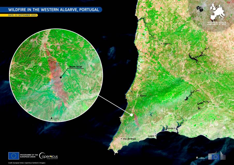
In mid-September 2025, a large wildfire swept through parts of the Western Algarve, affecting extensive areas of the municipalities of Aljezur and Lagos. The fire, which broke out near Bordeira, burnt around 2,000 hectares of vegetation and injured 14 people before being brought under control.
After several days of intense firefighting, the blaze was declared under control on 24 September. According to Abel Gomes, deputy commander of the Algarve Regional Emergency and Civil Protection Command, “the two complicated rekindlings observed overnight in the Feiteira area have been brought under control.” He added that operations were now focused on “consolidating some areas, monitoring, and extinguishing fires, with close attention being paid to the coming hours.”

During the night, flare-ups were reported in several areas, including Feiteira and near Bensafrim, but these were contained by firefighters stationed along the perimeter. Four Army platoons joined the effort to assist with extinguishing and surveillance operations, freeing up firefighters for other emergencies.
The Copernicus Sentinel-2 image acquired on 22 September 2025 shows the burn scar left by the wildfire. In this false colour composite, burnt areas appear in dark brown and red tones, while unburnt vegetation appears in bright shades of green, providing a clear contrast between affected and unaffected zones.
The Copernicus Sentinel-2 satellites deliver high-resolution optical data that help monitor land cover changes, including vegetation loss caused by fires. The Algarve fire response coincided with forecasts from the Portuguese Institute of the Sea and Atmosphere warning of strong winds from the approach of Hurricane Gabriel, prompting authorities to maintain close surveillance of the area.
Featured image credit: European Union, Copernicus Sentinel-2 imagery


