October’s floods in Vietnam brought widespread devastation to the country’s central provinces in late October 2025 after several days of relentless rainfall. Thousands of residents were forced to evacuate their homes, and local authorities reported at least 35 casualties as rivers overflowed and infrastructure suffered extensive damage. The province of Quảng Nam was among the hardest hit, with widespread inundation disrupting transport, agriculture, and livelihoods.

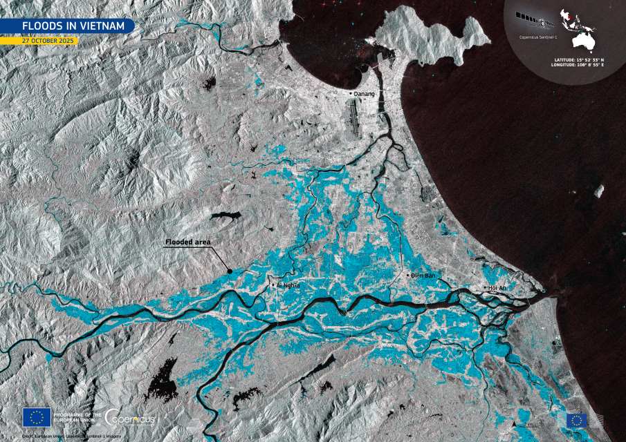
The image, captured by one of the Copernicus Sentinel-1 satellites on 27 October 2025, shows the flooded areas along the Vu Gia and Thu Bồn rivers near Ái Nghĩa, Điện Bàn, and Hội An. In this radar composite, waterlogged zones appear in varying shades of blue, sharply contrasting with the surrounding landscape.
Open data from the Copernicus Sentinel-1 mission provides cloud-penetrating radar imagery, allowing scientists and emergency teams to monitor flood extent and support rapid response efforts even when heavy rain and thick clouds obscure the view from optical satellites. This capability is crucial for tracking the evolution of flooding events across Southeast Asia’s river basins, where extreme rainfall has become increasingly frequent in recent years.
Featured image credit: European Union, Copernicus Sentinel-1 imagery


