At the northeastern edge of Egypt’s Nile Delta, the eastern distributary known as the Damietta Branch flows northeast toward the Mediterranean Sea, cutting through a fragile zone where fertile farmland, expanding towns, and sensitive coastal ecosystems meet. This region combines rich agricultural productivity with fast-growing urban and industrial areas, forming one of the most densely inhabited parts of Egypt.
The Damietta Branch is one of the two remaining main outlets of the Nile, stretching for about 242 km with an average width of 200 m. Its waters nourish the surrounding farmland while also supporting extensive aquaculture and wetland habitats. The delta itself extends roughly 240 km along the Mediterranean coast and about 160 km inland, forming a transition between freshwater systems and the sea. This interface supports diverse ecosystems of aquatic plants, migratory birds, and fish species that depend on the mixture of saline and freshwater environments.

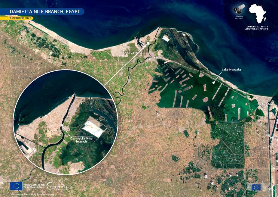
This image, captured by the Copernicus Sentinel-2 satellite on 1 October 2025, shows the Damietta Nile Branch winding across the delta before reaching the coast just west of New Damietta. To the east lies Lake Manzala, Egypt’s largest northern lagoon, easily recognizable by its green tones and the aquaculture structures that spread across its surface. The geometric layout of agricultural fields and fish farms highlights intensive land use, while urban centers such as Damietta and Port Said mark the area’s demographic and economic importance.
Ecologically, the Damietta estuary is a sensitive zone where freshwater discharge, seawater intrusion, and agricultural runoff intersect. Since the construction of the Aswan High Dam, sediment supply to the delta has sharply decreased, increasing vulnerability to erosion and saltwater encroachment. These processes threaten coastal habitats, farmlands, and lagoons, showing the importance of continuous observation.
Copernicus data are vital for monitoring the Nile Delta’s transformation, offering regular, high-resolution imagery that helps track land-use changes, coastal erosion, agricultural patterns, and water quality. By providing consistent and freely accessible Earth observation data, the Copernicus programme supports local authorities, researchers, and planners in managing one of Egypt’s most dynamic and ecologically valuable landscapes.
Featured image credit: European Union, Copernicus Sentinel-2 imagery


