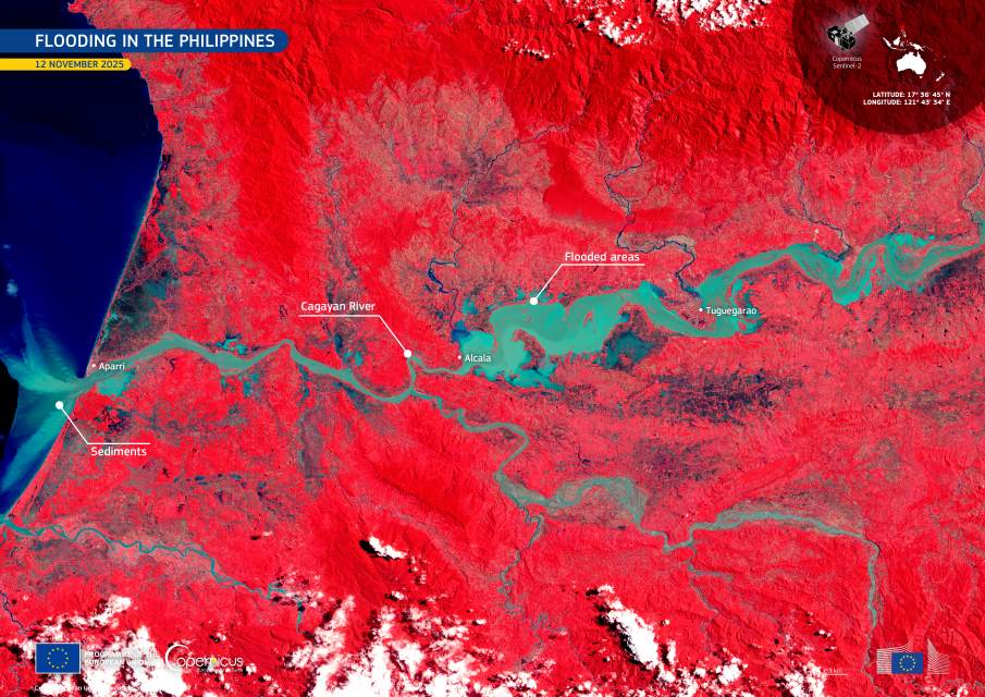
Floodwaters spread across Cagayan Valley in the days after Typhoon Fung-wong moved across the northern Philippines, leaving communities along the Cagayan River facing widespread disruption. The typhoon made landfall on 9 November 2025, bringing sustained rainfall that pushed the river beyond its banks and inundated agricultural districts, transport routes, and urban neighbourhoods, including parts of Tuguegarao. Local authorities reported displaced residents in several municipalities across the province, along with extensive damage to crops and road connections that link the region’s rural areas.
By mid-November, emergency teams were continuing to assess the scale of the flooding, while efforts to restore access to isolated villages were under way. In low-lying zones, standing water persisted for days as runoff from upstream valleys moved toward the coast. The overflow affected rice fields and other farmland during a critical part of the growing season, compounding losses for rural communities already dealing with earlier weather-related pressures.

In the middle of this evolving situation, a Copernicus Sentinel-2 satellite captured a false colour image on 12 November 2025, offering a detailed view of the swollen river system and its surrounding floodplains. Vegetation appears in red, while areas covered by water show up in light blue and green. Near Aparri, where the Cagayan River meets the Pacific Ocean, sediment plumes are visible as the floodwater carries soil and debris toward the coastline.
Such satellite data provide a consistent way to track flooding as it unfolds, giving authorities a clearer sense of where water levels are highest and which communities remain at risk. The open-access structure of the Copernicus programme supports emergency responders in mapping affected areas and planning recovery operations, a role that has become increasingly important as extreme weather events continue to disrupt regions across Southeast Asia.
Featured image credit: European Union, Copernicus Sentinel-2 imagery


